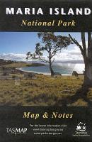
| << Tasmap << Tasmanien |
  | |
Zuletzt angesehene Artikel:
![]() | Maria Island National Park 1:50.000 Topographische Wanderkarte Tasmanien - Australien - Tasmap (Tasmanien) |
![]() | Gelendschik und Schwarzmeeküste 1:17.000 / 1:300.000 Stadtplan und Umgebungskarte Gelendzhik - Tschernomorskoje Pobereschje Geodom - Russland |
![]() | N4232 Valkeajärvi Topographische Karte 1:25.000 EUREF (Peruskartta) Maanmittauslaitos / Lantmäteriverket Finnland - ProjektNord |
![]() | 3944-SW Topographische Karte 1:10.000 - Landesvermessungsamt Brandenburg |
![]() | Costa degli Etruschi 1:50.000 (Blatt V205) Touristische Wanderkarte Italien mit touristischer Begleitbroschüre - Belletti Editore |
![]() | 2135SB Brive-la-Gaillarde-Beynat - Meyssac GPS Amtliche Topographische Wanderkarte Frankreich 1:25.000 - série bleue (IGN) |
![]() | 2822OT Quarré-les-Tombes / Saulieu / PNR du Morvan - Topographische Wanderkarte Frankreich 1:25.000 TOP 25 IGN - (GPS) |
![]() | 3353-SW Topographische Karte 1:10.000 - Landesvermessungsamt Brandenburg |
![]() | M-34-65-C/D Krakow - Nowa Huta Amtliche topographische Landkarte Polen 1:50.000 M-34-65-C/D Krakow - Nowa Huta - Mapa Topograficzna Polski Glowny Geodeta Kraju |
![]() | 3342ET PLATEAU DE VALENSOLE Topographische Wanderkarte Frankreich 1:25.000 TOP 25 IGN |
![]() | 35 Orust 1:50.000 (wasserfest) Topographische Wanderkarte - Sverigeserien Topo50 - Schweden Kartförlaget |
![]() | Rund um Bad Oldesloe Topographische Wanderkarte mit Wanderwegen und Radwegen 1:25.000 Schleswig-Holstein - ProjektNord |
![]() | TH10 Mount William 1:50.000 Topographische Landkarte Tasmanien - Australien - Tasmap (Tasmanien) |
![]() | Kirgistan - Nördliches Yssykköl-Gebiet 1:100.000 Topographische Trekkingkarte Kirgisistan Kyrgyzstan: Northern Issyk-Kul area - Trekking Map - Kirgisistan Trekking Union |
![]() | 266 Wirral & Chester / Caer - Wanderkarte Großbritannien 1:25.000 EXPLORER MAP - Ordnance Survey |
![]() | L7130 Treuchtlingen (geplottete Ausgabe) Topographische Karte Bayern 1:50.000 Bayerisches Landesvermessungsamt |
![]() | Val d`Ayas 1:25.000 (wasserfest) Mountainbikeführer und -karte - l`Escursionista Editore - Italien Val d`Ayas in mountain-bike - guida + carta |
![]() | Q5141 Maanselkä Topographische Karte 1:25.000 EUREF (Peruskartta) Maanmittauslaitos / Lantmäteriverket Finnland - ProjektNord |
![]() | Stockton Stadtplan 1:36.000 (Kalifornien - USA) Stockton street map GM Johnson |
![]() | Mallorca Regional Guide Reiseführer Lonely Planet (engl.) |


