Willkommen bei MapFox
+++ Buchhändleranfragen willkommen! Tel. 0431-666 75 99 +++
Warenkorb
Artikel: 0 - € 0.00
Zur Kasse
Impressum Kontakt Versandkosten AGB
Erde physisch Schultertasche schwarze Umhängetasche - mit Weltkarte STIEFEL
<< Stadtplan-Umhängetaschen / Landkarten-Schultertaschen
 
Cover

Praktische Schultertasche mit Weltkarte.

Die Tasche ist handlich und praktisch zugleich. Es passen ein Laptop/Notebook mit max. 15,6 Zoll, ein A4-Aktenordner/Buch und einige Hefte problemlos hinein. Ein großes Vorderfach mit Reißverschluss unter dem Überschlag bietet Platz für Ihre ID-/Kreditkarte, IPhone oder Geldbörse. Ein kleines Reißverschlussfach schafft Platz für diverse Kleinteile wie Schlüssel usw. Der verstellbare Schultergurt mit gepolsterter Einlage sorgt für einen angenehmen Tragekomfort.
Material: 600D Polyester mit digitalem Stoffdruck
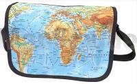
Format: 38 x 30 x 10 cm.

Kartenbeispiel

Erde physisch Schultertasche schwarze Umhängetasche - mit Weltkarte STIEFEL
EAN / ISBN: 4027871028014
Preis: EUR 29.90

sofort versandfertig Dieser Artikel ist im Normalfall sofort lieferbar.
Produkt EUR Anzahl Bestellen
Erde physisch Schultertasche schwarze Umhängetasche - mit Weltkarte STIEFEL 29.90
Versandkostenfrei in Deutschland ab 30,- Bestellwert

incl. MwSt.

Stichworte, die bei der Suche nützlich sein könnten:
Landkarten-Tasche Weltkarte - College-Tasche Weltkarte - Landkartentasche Welt - Collegetasche Welt - Collegetasche - College-Tasche - Stadtplantasche - Stadtplan-Tasche - Collegetaschen - College-Taschen - Stadtplantaschen - Stadtplan-Taschen

Zuletzt angesehene Artikel:

CoverErde physisch Schultertasche schwarze Umhängetasche - mit Weltkarte STIEFEL

Cover2222 02 Könni Topographische Karte 1:20.000 (Maastokartta / Peruskartta / Grundkarta) Maanmittauslaitos / Lantmäteriverket Finnland - ProjektNord

Noch kein Cover vorhanden0916 List (Sylt) - Gestern und Heute - Historische Überlagerung 1953-1956 Topographische Landkarte 1:25.000 im Vergleich - Landesvermessungsamt Schleswig-Holstein / ProjektNord

Cover0199-4 ISAR Topographische Landkarte 1:25.000 Spanien (Grundlage MTN25) Instituto Geográfico Nacional - CNIG Spanien - ProjektNord

Cover248-4 BARLUENGA Amtliche topographische Landkarte 1:25.000 Spanien (M.T.N.)
248-4 Mapa Topográfico Nacional de Espana (MTN25) Instituto Geográfico Nacional - CNIG Spanien

Cover3616 Preußisch Oldendorf Topographische Wanderkarte 1:25.000 Niedersachsen mit Wanderwegen - ProjektNord

Cover0654-3 LA ESTRELLA Topographische Landkarte 1:25.000 Spanien (Grundlage MTN25) Instituto Geográfico Nacional - CNIG Spanien - ProjektNord

Cover125-4 BALBOA Amtliche topographische Landkarte 1:25.000 Spanien (M.T.N.)
125-4 Mapa Topográfico Nacional de Espana (MTN25) Instituto Geográfico Nacional - CNIG Spanien

Cover293-1 BERGA Amtliche topographische Landkarte 1:25.000 Spanien (M.T.N.)
293-1 Mapa Topográfico Nacional de Espana (MTN25) Instituto Geográfico Nacional - CNIG Spanien

Cover186-3 PONTE CALDELAS Amtliche topographische Landkarte 1:25.000 Spanien (M.T.N.)
186-3 Mapa Topográfico Nacional de Espana (MTN25) Instituto Geográfico Nacional - CNIG Spanien

Cover0466-4 BLESA Topographische Landkarte 1:25.000 Spanien (Grundlage MTN25) Instituto Geográfico Nacional - CNIG Spanien - ProjektNord

Cover0971-1 ALICÚN DE ORTEGA Topographische Landkarte 1:25.000 Spanien (Grundlage MTN25) Instituto Geográfico Nacional - CNIG Spanien - ProjektNord

Cover15-3 SELORIO Amtliche topographische Landkarte 1:25.000 Spanien (M.T.N.)
15-3 Mapa Topográfico Nacional de Espana (MTN25) Instituto Geográfico Nacional - CNIG Spanien

Cover308-4 VILLAFÁFILA Amtliche topographische Landkarte 1:25.000 Spanien (M.T.N.)
308-4 Mapa Topográfico Nacional de Espana (MTN25) Instituto Geográfico Nacional - CNIG Spanien

Noch kein Cover vorhanden1 III Topographische Landkarte Portugal 1:50.000 Carta Militar de Portugal Instituto Geográfico do Exército (IGeoE) - Portugal

CoverNL 33-02-09 West (4209-West) Hieflau Österreichische Karte 1:25.000 mit Wegmarkierungen (topographische Wanderkarte - UTM) - BEV - Österreich - Vergrößerung (ÖK25V)

Cover3133 11 Vainikkala Topographische Karte 1:20.000 (Maastokartta / Peruskartta / Grundkarta) Maanmittauslaitos / Lantmäteriverket Finnland - ProjektNord

Cover1023-3 BOBADILLA-ESTACION Amtliche topographische Landkarte 1:25.000 Spanien (M.T.N.)
1023-3 Mapa Topográfico Nacional de Espana (MTN25) Instituto Geográfico Nacional - CNIG Spanien

Cover119-4/3 PORTO DO SON Amtliche topographische Landkarte 1:25.000 Spanien (M.T.N.)
119-4/3 Mapa Topográfico Nacional de Espana (MTN25) Instituto Geográfico Nacional - CNIG Spanien

Cover4322 02+05 Rumo Topographische Karte 1:20.000 (Maastokartta / Peruskartta / Grundkarta) Maanmittauslaitos / Lantmäteriverket Finnland - ProjektNord