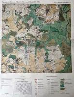
| << Schleswig-Holstein: Varendorfsche Karten 1:25.000 (Historische Landkarten Herzogtum Holstein - Reproduktion) |
  | |
|
||
Zuletzt angesehene Artikel:
![]() | 07 Erfde - Dellstedt - Tellingstedt - Varendorfsche Karte 1789-1792 Topographisch Militärische Charte des Herzogtums Holstein - Reproduktion 1:25.000 |
![]() | 1238 PIZ QUATTERVALS 1:25.000 - Val trupchun - Piz Chaschauna - Livigno - Topographische Landeskarte der Schweiz - swisstopo |
![]() | Krim Rybatschje - Morskoje Topographische Wanderkarte 1:50.000 Krim - Ukraine ukrmap Kartografija - ukrmap Ukraine Рыбачве Морское |
![]() | Istrien 1:30.000 Radwanderkarten-SET - Mateus Cartography - Kroatien |
![]() | 323 Eskdale and Castle o`er Forest - Wanderkarte Großbritannien 1:25.000 EXPLORER MAP - Ordnance Survey |
![]() | 5669 Kaindorf Topographische Karte 1:25.000 Messtischblatt des Deutschen Reiches - Preußische Landesaufnahme / Reichsamt für Landesaufnahme - Faksimile ProjektNord |
![]() | 2826SB LUZY - TOULON-SUR-ARROUX GPS Amtliche Topographische Wanderkarte Frankreich 1:25.000 - série bleue (IGN) |
![]() | R532 Ala-Vuokki Topographische Karte 1:50.000 EUREF-FIN (Maastokarttat) Maanmittauslaitos / Lantmäteriverket Finnland - ProjektNord |
![]() | 2328 Trittau Topographische Landkarte 1:25.000 Landesvermessungsamt Schleswig-Holstein |
![]() | 14 (13-03) Gijon Amtliche topographische Landkarte 1:50.000 Spanien (M.T.N.) 14 Mapa Topográfico Nacional de Espana (MTN50) Instituto Geográfico Nacional - CNIG Spanien |
![]() | Sundern am Sorpesee (Sauerland) Topographische Wanderkarte Nordrhein-Westfalen mit Wanderwegen und Radwegen 1:25.000 - ProjektNord |
![]() | 204 Truro & Falmouth, Roseland Peninsula - Wanderkarte Großbritannien 1:50.000 Active Laminiert LANDRANGER MAP - Ordnance Survey |
![]() | 07G HOOGEZAND Topographische Karte der Niederlande 1:25.000 (Plotausgabe) 07G HOOGEZAND Topografische Kaart van Nederland Kadaster - ProjektNord |
![]() | Ryfylkefjordane - Sjernarøyane - Sauda - Seekarte Norwegische Küste 1:50.000 - (Blatt 15) Den Norske Kyst Sjøkart - Hovedkart (sjø) Statens Kartverk Sjø - Norwegen |
![]() | Flaming Gorge - Eastern Uintas Trail - Utah / Wyoming (GPS) 1:50.000 - (Blatt 704) Wanderkarte/Trekkingkarte-Trails Illustrated Map - National Geographic |
![]() | 40/5-6 CHASTRE - GEMBLOUX NGI 1:20.000 Topographische Landkarte Belgien |
![]() | Sibiu (Hermannstadt) Stadtplan (rum./dt.) Constant Verlag Rumänien |
![]() | Dinarisches Gebirge 2 - Naturpark Dinara - Troglav mit Wanderwegen und Radwegen - Wanderkarte - Fahrradkarte 1:30.000 Kroatien - Bosnien-Herzegowina - ProjektNord |
![]() | Walk! La Gomera (Wanderführer englisch) *SCHNÄPPCHEN* Discovery Walking Guides Ltd. |


