Willkommen bei MapFox
+++ Buchhändleranfragen willkommen! Tel. 0431-666 75 99 +++
Warenkorb
Artikel: 0 - € 0.00
Zur Kasse
Impressum Kontakt Versandkosten AGB
8 Schleswig - Eckernförde - Kiel - Rendsburg - du Platsche Karte 1804-1805 Topographische Karte des Herzogtums Schleswig - Reproduktion 1:100.000
<< Schleswig-Holstein: Du Platsche Karten 1:100.000 (Historische Landkarten Herzogtum Schleswig - Reproduktion)
 

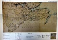
Landesaufnahme des Herzogtums Schleswig von Heinrich du Plat - du Platsche Karte

Die topographische Aufnahme, vorwiegend aus dem letzten Viertel des 18. Jahrhundert, wurde zusammengetragen und gezeichnet in den Jahren 1804 und 1805 von H. du Plat, Pr. Lieutenant im Cron Printzen Regiment, mit Hilfe der Lieutenants Fred. Bauditz, Fr. Wilster und Tauenzien.

Bei den Karten handelt es sich um eine Reproduktion im Maßstab: 1:100.000 (Originalmaßstab 1:57.600).

Das Herzogtum Schleswig wird in 8 Einzelblättern dargestellt.

Blattschnitte der Serie

8 Schleswig - Eckernförde - Kiel - Rendsburg - du Platsche Karte 1804-1805 Topographische Karte des Herzogtums Schleswig - Reproduktion 1:100.000
Preis: EUR 9.99

Bestellartikel: versandfertig in ca. 3-7 Tagen. Dieser Artikel wird speziell für Sie bestellt. Keine Rücknahme!
Produkt EUR Anzahl Bestellen
8 Schleswig - Eckernförde - Kiel - Rendsburg - du Platsche Karte 1804-1805 Topographische Karte des Herzogtums Schleswig - Reproduktion 1:100.000 9.99
Versandkostenfrei in Deutschland ab 30,- Bestellwert

incl. MwSt.

Stichworte, die bei der Suche nützlich sein könnten:
Schleswig-Holstein Messtischblätter - Historische Landkarten Deutschland - Herzogtum Schleswig - Schleswig-Holstein Amtliche topographische Landkarten - Schleswig-Holstein - Schleswig-Holstein Historische Landkarten - Historische Landkarten Schleswig-Holstein - Schleswig-Holstein du Platsche Karten - Herzogtums Holstein - Schleswig-Holstein - Schleswig-Holstein Historische Landkarten - Schleswig-Holstein du Platsche Karten - Schleswig-Holstein Amtliche topographische Landkarten - Herzogtum Schleswig - du Plat

Zuletzt angesehene Artikel:

Noch kein Cover vorhanden8 Schleswig - Eckernförde - Kiel - Rendsburg - du Platsche Karte 1804-1805 Topographische Karte des Herzogtums Schleswig - Reproduktion 1:100.000

Cover511 Topographische Landkarte Wanderkarte und Fahrradkarte Portugal 1:25.000
511 Mapa topográfico - Mapa de caminhadas - Portugal 1:25.000 ProjektNord

Cover32 Topographische Landkarte Wanderkarte und Fahrradkarte Portugal 1:25.000
032 Mapa topográfico - Mapa de caminhadas - Portugal 1:25.000 ProjektNord

Noch kein Cover vorhanden2129 Lübeck West - Gestern und Heute - Historische Überlagerung 1932-1950 Topographische Landkarte 1:25.000 im Vergleich - Landesvermessungsamt Schleswig-Holstein / ProjektNord

Noch kein Cover vorhanden1829 Eutin - Gestern und Heute - Historische Überlagerung 1878-1880 Topographische Landkarte 1:25.000 im Vergleich - Landesvermessungsamt Schleswig-Holstein / ProjektNord

Cover4 CASTRO LABOREIRO (MELGAÇO) Topographische Landkarte Wanderkarte und Fahrradkarte Portugal 1:25.000
004 Mapa topográfico - Mapa de caminhadas - Portugal 1:25.000 ProjektNord

Cover366 Topographische Landkarte Wanderkarte und Fahrradkarte Portugal 1:25.000
366 Mapa topográfico - Mapa de caminhadas - Portugal 1:25.000 ProjektNord

Cover252 Topographische Landkarte Wanderkarte und Fahrradkarte Portugal 1:25.000
252 Mapa topográfico - Mapa de caminhadas - Portugal 1:25.000 ProjektNord

Cover5 Topographische Landkarte Wanderkarte und Fahrradkarte Portugal 1:25.000
005 Mapa topográfico - Mapa de caminhadas - Portugal 1:25.000 ProjektNord

Cover363 Aveiras de Cima (Azambuja) Topographische Landkarte Wanderkarte und Fahrradkarte Portugal 1:25.000
363 Mapa topográfico - Mapa de caminhadas - Portugal 1:25.000 ProjektNord

Cover9-A Topographische Landkarte Wanderkarte und Fahrradkarte Portugal 1:25.000
009A Mapa topográfico - Mapa de caminhadas - Portugal 1:25.000 ProjektNord

Cover237 Topographische Landkarte Wanderkarte und Fahrradkarte Portugal 1:25.000
237 Mapa topográfico - Mapa de caminhadas - Portugal 1:25.000 ProjektNord

Cover339 Rio Maior Topographische Landkarte Wanderkarte und Fahrradkarte Portugal 1:25.000
339 Mapa topográfico - Mapa de caminhadas - Portugal 1:25.000 ProjektNord

Cover314 Topographische Landkarte Wanderkarte und Fahrradkarte Portugal 1:25.000
314 Mapa topográfico - Mapa de caminhadas - Portugal 1:25.000 ProjektNord

Cover302 Proenca-A-Nova Topographische Landkarte Wanderkarte und Fahrradkarte Portugal 1:25.000
302 Mapa topográfico - Mapa de caminhadas - Portugal 1:25.000 ProjektNord

Cover36 Topographische Landkarte Wanderkarte und Fahrradkarte Portugal 1:25.000
036 Mapa topográfico - Mapa de caminhadas - Portugal 1:25.000 ProjektNord

Cover367 Topographische Landkarte Wanderkarte und Fahrradkarte Portugal 1:25.000
367 Mapa topográfico - Mapa de caminhadas - Portugal 1:25.000 ProjektNord

Cover413 Topographische Landkarte Wanderkarte und Fahrradkarte Portugal 1:25.000
413 Mapa topográfico - Mapa de caminhadas - Portugal 1:25.000 ProjektNord

Cover92 Topographische Landkarte Wanderkarte und Fahrradkarte Portugal 1:25.000
092 Mapa topográfico - Mapa de caminhadas - Portugal 1:25.000 ProjektNord

Cover459 - Topographische Landkarte Portugal 1:25.000 Carta Militar de Portugal - Série M888 Instituto Geográfico do Exército (IGeoE) - Portugal