| << Schweden: Topographische Wanderkarten 1:50.000 - Lantmäteriet Terrängkartan 1:50.000 |
  | |
|
||
Zuletzt angesehene Artikel:
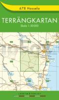
![]() | 678 Hassela - Terrängkartan 1:50.000 Topographische Wanderkarte Schweden - Lantmäteriet Landkarte Schweden |
![]() | 2409 Norden Topographische Wanderkarte 1:25.000 Niedersachsen mit Wanderwegen - ProjektNord |
![]() | 237S WALENSTADT 1:50.000 - Schilt - Churfirsten - Spitzmeilen - Topographische Skitourenkarte SSV der Schweiz - swisstopo |
![]() | 4621 Wolfhagen Topographische Landkarte Hessen 1:25.000 - ProjektNord (geplottete Ausgabe) |
![]() | 2841OT Vézénobres - Moussac GPS Amtliche Topographische Wanderkarte Frankreich 1:25.000 - série bleue (IGN) |
![]() | Trysil nord Topographische Wanderkarte Topo 3000 - 1:50.000 (Blatt 3043) - Nordeca - Norwegen |
![]() | Montana Atlas & Gazetteer - Topographischer Straßenatlas Delorme Publishing Company DELORME MAPPING USA |
![]() | Wienerwald (Nr. 208) 1:25.000 - Wanderkarten-Set mit Naturführer Mit Radrouten. Mit 1 Naturführer Wiesenblumen KOMPASS |
![]() | L7340 Dingolfing (geplottete Ausgabe) Topographische Karte Bayern 1:50.000 Bayerisches Landesvermessungsamt |
![]() | Landeck - Nauders - Samnaungruppe 1:50.000 (Blatt 42) - Wanderkarte mit Broschüre 10 Top-Touren KOMPASS |
![]() | Pyrénées-Atlantiques - Béarn - Pays Basque - 1:125.000 Touristische Landkarte Découvertes régionales - IGN Frankreich |
![]() | Kalmar län Terräng CD (5) Topographische Landkarte Schweden 1:50.000 auf CD-ROM Kartförlaget Schweden |
![]() | 2919 Bremen Ost Amtliche topographische Karte 1:25.000 Landesvermessungsamt Niedersachsen |
![]() | Santiago de Chile 1:12.500 & Nord Chile 1:770.000 Stadtplan - ITMB International Travel Maps Santiago and northern Chile |
![]() | 1227 NIESEN 1:25.000 - Erlenbach i.S. - Diemtigtal - Frutigen - Topographische Landeskarte der Schweiz - swisstopo |
![]() | V52 Topographische Karte 1:100.000 EUREF-FIN Maanmittauslaitos / Lantmäteriverket Finnland - ProjektNord |
![]() | 152 Newport & Pontypool / Casnewydd a Phont-y-pwl - Wanderkarte Großbritannien 1:25.000 EXPLORER MAP - Ordnance Survey |
![]() | Sizilien - Malta - Tunesien - Hafenführer (Band 8) und die Westküste Italiens südlich von Neapel - von Axel Kramer - See-Verlag |
![]() | 449 Kreta (Mitte) 1:100.000 Landkarte Griechenland -Terrain Cartography - Griechenland - Terrain maps Central Greece |
![]() | 2117 Cuxhaven West Amtliche topographische Karte 1:25.000 Landesvermessungsamt Niedersachsen |


