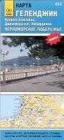
| << Russland: Städte, Stadtpläne, Stadtatlanten, Stadtführer |
  | |
Zuletzt angesehene Artikel:
![]() | Gelendschik und Umgebung 1:25.000 / 1:160.000 Stadtplan - (Blatt 494) Karta Gelendzhik - Archipo-Osipowka, Diwnomorskoe, Kabardikna - Tschernomorskoje Pobereschje |
![]() | PARQUE REGIONAL CARRASCOY Y EL VALLE Wanderkarte 1:25.000 - Editorial Piolet - Spanien |
![]() | 2916 Hatten Amtliche topographische Karte 1:25.000 Landesvermessungsamt Niedersachsen |
![]() | 1624 Rendsburg - Gestern und Heute - Historische Überlagerung 1878-1880 Topographische Landkarte 1:25.000 im Vergleich - Landesvermessungsamt Schleswig-Holstein / ProjektNord |
![]() | Kanada Ost 1:1.5 Mio. Ontario - Quebec - New Brunswick - Prinz-Edward-Insel - Neuschottland, Neufundland Canada the East - Roadmap - Ontaria - Quebec - New Brunswick - Prince Edward Island - Nova Scotia, Newfoundland - Hildebrand`s Urlaubskarte - |
![]() | 1 Nevado Chimborazo 1:20.000 Ecuador (wasserfest) Trekking - Orthophotokarte - Cordillera de los Andes - Technische Universität Dresden / ARGE - Arbeitsgemeinschaft für vergleichende Hochgebirgsforschung |
![]() | NM 33-10-28 Ost (3328-Ost) Munderfing Österreichische Karte 1:25.000 mit Wegmarkierungen (topographische Wanderkarte - UTM) - BEV - Österreich - Vergrößerung (ÖK25V) |
![]() | Landkreis Järva (Estland) Touristenkarte Estland 1:150.000 Järvamaa Turismikaart - Touristmap - Touristische Landkarte Regio |
![]() | CG12 Topographische Landkarte Neuseeland 1:50.000 Land Information New Zealand |
![]() | London Stadtplan 1:12.500 - Internationale Stadtpläne Cartographia |
![]() | Mt. Parnassos - Topographische Bergwanderkarte Griechenland 1:35.000 (Blatt 2.1) - Central Greece Anavasi - Griechenland Παρνασσος - Parnassos - ΠΕΖΟΠΟΡΙΚΟΣ ΧΑΡΤΗΣ - Touring & Hiking Map |
![]() | Hasselt NGI 1:25.000 Touristische Landkarte und Wanderkarte Belgien |
![]() | Hermannsweg, Rheine - Leopoldstal Leporello Wanderkarte mit Ausflugszielen, Einkehr- & Freizeittipps, Straßennamen, Höhenprofil und Etappen, wetterfest, reissfest, abwischbar, GPS-genau. 1:25000 - von - Freytag-Berndt und ARTARIA Publicpress |
![]() | Häfen, Yachthäfen und Touristenhäfen an der Oder 1:750.000 / 1:200.000 Wassersportkarte Odrzanskie porty, mariny i przystanie turystyczna Polkart - Polen |
![]() | Westliche Tatra - slowakischer und polnischer Teil 1:30.000 Laminierte touristische Landkarte Tatry Zachodnie Slowackie i Polskie ExpressMap Polen |
![]() | Foresta Modello delle Montagne Fiorentine 1:50.000 Wanderkarte S.EL.CA |
![]() | 359 - Topographische Landkarte Portugal 1:25.000 Carta Militar de Portugal - Série M889 Instituto Geográfico do Exército (IGeoE) - Portugal |
![]() | 183 Chelmsford & The Rodings - Wanderkarte Großbritannien 1:25.000 EXPLORER MAP - Active Map LAMINIERT - Ordnance Survey |
![]() | 4551 Hoyerswerda - Geologische Karte 1:25.000 (GK25) Grundlage Messtischblatttopographie Sächsisches Landesamt für Umwelt, Landwirtschaft und Geologie |
![]() | 2041 03 Ikkala Topographische Karte 1:20.000 (Maastokartta / Peruskartta / Grundkarta) Maanmittauslaitos / Lantmäteriverket Finnland - ProjektNord |


