Willkommen bei MapFox
Wurde Ihre Bestellung bestätigt? Wenn nicht - gab es evtl. ein SERVER-Problem! Bitte kontaktieren Sie uns! +++ Buchhändler-Anfragen erwünscht +++
Warenkorb
Artikel: 0 - € 0.00
Zur Kasse
Impressum Kontakt Versandkosten AGB
6120 Obernburg am Main Topographische Landkarte Bayern 1:25.000 - Normalausgabe - ProjektNord (geplottete Ausgabe) - Grundlage amtliche Topographische Karte Bayern DTK25
<< Deutschland: Amtliche Topographische Karten 1:25.000 nach Blattnummern (6000-6999)
<< Bayern: Topographische Karte 1:25.000 (Regelblattschnitt) - Bayrisches Landesamt für Digitalisierung, Breitband und Vermessung (Landesvermessungsamt)
 
Cover

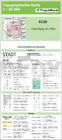
Topographische Karte Bayern 1:25.000 im Regelblattschnitt. Die Kartengrundlage wurde aus amtlichen Quellen und anderen mit offener Datenlizenz erstellt. Bereiche außerhalb Bayerns (v.a. Ausland) bleiben ggf. weiß.

Blatteinteilung:

Nordwest (Würzburg) Nord-Mitte (Bamberg) Nordost (Bayreuth)
West-Mitte (Donauwörth) Mitte (Regensburg) Ost-Mitte (Deggendorf)
Südwest (Kaufbeuren) Süd-Mitte (München) Südost (Garching)

Kartenbeispiel aus der Serie

Hinweis: Diese Karte wird individuell auf Kundenbestellung gedruckt und ist daher von der Rückgabe ausgeschlossen.

Blattschnitt

6120 Obernburg am Main Topographische Landkarte Bayern 1:25.000 - Normalausgabe - ProjektNord (geplottete Ausgabe) - Grundlage amtliche Topographische Karte Bayern DTK25
Preis: EUR 17.90

sofort versandfertig Dieser Artikel ist im Normalfall sofort lieferbar.
Produkt EUR Anzahl Bestellen
6120 Obernburg am Main Topographische Landkarte Bayern 1:25.000 - Normalausgabe - ProjektNord (geplottete Ausgabe) - Grundlage amtliche Topographische Karte Bayern DTK25 17.90
Versandkostenfrei in Deutschland ab 30,- Bestellwert

incl. MwSt.

Stichworte, die bei der Suche nützlich sein könnten:
Obernburg am Main - Bayern Messtischblatt - Bayerische Topographische Karte - Bayern Topographische Landkarte - Landesvermessungsamt Bayern - Bayern Topographische Karte - Bayern Landkarten - Bayern Messtischblatt - Bayrisches Landesamt für Digitalisierung Breitband und Vermessung - Topographische Karte Deutschland - Deutschland Topographische Landkarten - Deutschland Regelblattschnitte - Deutschland Messtischblätter

Zuletzt angesehene Artikel:

Cover6120 Obernburg am Main Topographische Landkarte Bayern 1:25.000 - Normalausgabe - ProjektNord (geplottete Ausgabe) - Grundlage amtliche Topographische Karte Bayern DTK25

Cover806-3 BENQUERENCIA DE LA SERENA Amtliche topographische Landkarte 1:25.000 Spanien (M.T.N.)
806-3 Mapa Topográfico Nacional de Espana (MTN25) Instituto Geográfico Nacional - CNIG Spanien

Cover2415-IV Fornæs - mit Wanderwegen und Fahrradrouten Topographische Fahrradkarte und Wanderkarte Dänemark 1:50.000 - Kort & Matrikelstyrelsen ProjektNord
2415-IV Fornæs og Anholt - Topografisk Cykel- og Vandrekort Danmark

CoverVon Nurallao nach Sorgono (Blatt 4) Touristische Wanderkarte
Trenino Verde - Carta turistico - escursionistica da Nurallao a Sorgono

Cover561 Odemira (Süd) Topographische Landkarte Portugal 1:25.000 Carta Militar de Portugal - Série M888 Instituto Geográfico do Exército (IGeoE) - Portugal

CoverChile und die Osterinsel Reiseführer Reise-Know-How Verlag

CoverM18 Bad Griesbach mit Bad Birnbach, Bad Füssing, Rotthalmünster, Pocking, Ruhstorf a.d.Rott *** SCHNÄPPCHEN *** ATK25 Topographische Karte 1:25.000 (Atkis) Bayern Landesvermessungsamt Bayern - Wanderkarte

Cover2411-II Maribo - mit Wanderwegen und Fahrradrouten Topographische Fahrradkarte und Wanderkarte Dänemark 1:50.000 - Kort & Matrikelstyrelsen ProjektNord
2411-II Maribo - Topografisk Cykel- og Vandrekort Danmark

CoverL2714 Varel (geplottete Ausgabe) Topographische Karte 1:50.000 Kartografie Landesvermessungsamt Niedersachsen - ProjektNord

CoverSri Lanka Nelles-Reiseführer Nelles-Verlag

CoverUsedom Kartenset 3 Rad- und Wanderkarten 1:30.000 (Zinnowitz - Ückeritz - Peenemünde, Heringsdorf - Ahlbeck - Bansin, Lieper Winkel und Usedom) - Grünes Herz

Noch kein Cover vorhanden105/123 Kantiemov / Novopskov - Amtliche topographische Landkarte 1:100.000 der Ukraine Kiewskaja Wojenno-Kartografitscheskaja Fabrika Ukraine

Cover5104 Düren (geplottete Ausgabe) Amtliche topographische Karte 1:25.000 Landesvermessungsamt Nordrhein-Westfalen

Cover551 (11-22) Martiago Amtliche topographische Landkarte 1:50.000 Spanien (M.T.N.)
551 Mapa Topográfico Nacional de Espana (MTN50) Instituto Geográfico Nacional - CNIG Spanien

CoverUSA - Der Osten, Mittlerer Westen, Südstaaten Nelles-Reiseführer Nelles-Verlag

CoverJ08 Treuchtlingen - Wemding, Wolferstadt, Monheim, Heidenheim, Markt Berolzheim *** SCHNÄPPCHEN *** ATK25 Topographische Karte 1:25.000 (Atkis) Bayern Landesvermessungsamt Bayern - Wanderkarte

Cover338 Obidos - Topographische Landkarte Portugal 1:25.000 Carta Militar de Portugal - Série M888 Instituto Geográfico do Exército (IGeoE) - Portugal

Cover129 - Topographische Landkarte Portugal 1:25.000 Carta Militar de Portugal - Série M888 Instituto Geográfico do Exército (IGeoE) - Portugal

CoverBialowieza Urwald 1:50.000 - Touristische Landkarte und Wanderkarte Polen (deutsch / polnisch)
Puszcza Bialowieska - The Bialowieza Forest - Beloveschskaja Puschtscha Agencja TD - Polen

CoverVulkaneifel - Schneifel 1:50.000 Wanderkarte - GeoMap