| << Cookinseln - Tokelau-Inseln - Niue - Kermadecinseln |
||
|
||
Zuletzt angesehene Artikel:
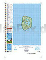
 | PI18 Mitiaro (Cookinseln) Topographische Landkarte 1:25.000 - Land Information New Zealand |
 | Short Walks in Lakeland Volume 2: North - Wanderführer Lake District - Cicerone Großbritannien (englisch) |
 | Mittelholstein Topographische Wanderkarte mit Wanderwegen und Radwegen 1:40.000 Schleswig-Holstein - ProjektNord |
 | Xixabangma (Shisha Pangma) Tibet 1:100.000 (West Tibet) CHINESE INSTITUTE GLACIOLOGY |
 | Dilijan National Park - Topographische Wanderkarte 1:25.000 Cartisan |
 | Karnischer Höhenweg Rother-Wanderführer Von Sillian nach Thörl-Maglern - 14 Etappen mit Varianten und Gipfeln - GPS - von Evamaria Wecker - Bergverlag Rother |
 | Elbrus 1:50.000 Trekkingkarte Kaukasus / Russland Climbing and Trekking Map Climbing-map |
 | Istrien - Pula 1:100.000 Autokarte Istra, Pula - Istria, Pola Istrie, Pula - Istria, Pula freytag & berndt |
 | 1 Niederösterreich - Wien 1:200.000 Auto- + Freizeitkarte freytag & berndt |
 | Friaul-Julisch Venetien: Von den Karnischen und Julischen Alpen zur Adria 56 Touren mit GPS-Tracks - Rother Wanderführer - Bergverlag Rother |
 | PI17 Mangaia (Cookinseln) Topographische Landkarte 1:25.000 - Land Information New Zealand |
| 6822 Obersulm Topographische Landkarte 1:25.000 - Landesvermessungsamt Baden-Württemberg |
 | 197 Chichester & The South Downs - Bognor Regis & Arundel - Wanderkarte Großbritannien 1:50.000 LANDRANGER MAP - Ordnance Survey |
 | Kaukasus: Bezingi Wanderkarte (Blatt 3) mit Trekkingführer Caucasus Bezingi 1:100.000 map/guide 3 Bezingi - Sugan - Laboda - Adaikhokh WEST COL PRODUCTIONS |
 | Steiermark - Wanderkarten Set 1:50.000 Alle 20 Wanderkarten für die Steiermark in einer praktischen Box! - Freytag-Berndt und ARTARIA |