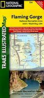
| << USA: Wanderkarten, Nationalpark-Karten << National Geographic |
  | |
Zuletzt angesehene Artikel:
![]() | Flaming Gorge - Eastern Uintas Trail - Utah / Wyoming (GPS) 1:50.000 - (Blatt 704) Wanderkarte/Trekkingkarte-Trails Illustrated Map - National Geographic |
![]() | Frankreich - Belgien - Niederlande - englisch Laminierte PLANO-Karte 1:1.953 Mio. (Format: 60 x 77 cm) - gerollt im Plastikrohr France - Belgium - Netherlands flat map - laminated National Geographic |
![]() | 40/5-6 CHASTRE - GEMBLOUX NGI 1:20.000 Topographische Landkarte Belgien |
![]() | 157.32 Amtliche topographische Karte 1:25.000 Polen |
![]() | 3713 04 Juppurat Topographische Karte 1:20.000 (Maastokartta / Peruskartta / Grundkarta) Maanmittauslaitos / Lantmäteriverket Finnland - ProjektNord |
![]() | M-34-93-A/B Sanok Amtliche topographische Landkarte Polen 1:50.000 M-34-93-A/B Sanok - Mapa Topograficzna Polski Glowny Geodeta Kraju |
![]() | Zentralamerika - 1:1.125 Mio. / 1:650.000 Straßenkarte - freytag & berndt |
![]() | Oblast Kursk 1:100.000 Touristischer Atlas Регионы России - Курская область - Атлас ФГУП Омская картографическая фабр |
![]() | 172.41 Amtliche topographische Karte 1:25.000 Polen |
![]() | 131.34 Amtliche topographische Karte 1:25.000 Polen |
![]() | 156 N Ballangen NORD 1:50.000 - Amtliche Topographische Landkarte Norwegen - Startens Kartverk |
![]() | Olympische Sommerspiele Larsen-Puzzle OB8-DE |
![]() | Jegorjewsk Stadtplan 1:10.000 / 1:36.000 - Russland Егорьевск GKS - Globalnij Kartografitscheskij Servis Russland |
![]() | P5142 Juankoski Topographische Karte 1:25.000 EUREF (Peruskartta) Maanmittauslaitos / Lantmäteriverket Finnland - ProjektNord |
![]() | L-34-8-D NyÃradony Amtliche Topographische Karte Ungarn 1:50.000 |
![]() | 350.22 Widuchowa Amtliche topographische Karte 1:25.000 Polen |
![]() | Karpaten Wolowezkyi Rajon Topographische Wanderkarte 1:50.000 Karpaten - Ukraine Karpati Volovetskyi Raion Kartografija - ukrmap Ukraine |
![]() | 322.4 Bialogard Amtliche topographische Karte 1:50.000 Polen |
![]() | 345.31 Amtliche topographische Karte 1:25.000 Polen |
![]() | 83 KERRY (CAHERCIVEEN) Wanderkarte Irland 1:50.000 DISCOVERY MAP - Ordnance Survey |


