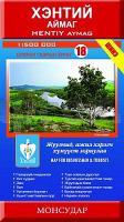
| << Mongolei << Monsudar |
  | |
Zuletzt angesehene Artikel:
![]() | 18 Chentii Aimag 1:500.000 Touristische Landkarte Hentiy Aymag - Хэнтий Аймаг - газрын зураг - Монсудар Monsudar - Mongolei |
![]() | 3324 Lindwedel Topographische Wanderkarte 1:25.000 Niedersachsen mit Wanderwegen - ProjektNord |
![]() | 3009 Dörpen Topographische Wanderkarte 1:25.000 Niedersachsen mit Wanderwegen - ProjektNord |
![]() | 448 Strath Naver / Srath Nabhair & Loch Loyal - Wanderkarte Großbritannien 1:25.000 EXPLORER MAP - Ordnance Survey |
![]() | Kirgistan - Südküste Yssykköl See 1:100.000 Topographische Trekkingkarte Kirgisistan Kyrgyzstan: South Shore (Lake Issyk-Kul) - Trekking Map - Kirgisistan Trekking Union |
![]() | 57 Cabezon de la Sal Amtliche topographische Landkarte 1:50.000 Spanien (M.T.N.) 57 Mapa Topográfico Nacional de Espana (MTN50) Instituto Geográfico Nacional - CNIG Spanien |
![]() | 09E DE COCKSDORP Topographische Karte der Niederlande 1:25.000 (Plotausgabe) 09E DE COCKSDORP Topografische Kaart van Nederland Kadaster - ProjektNord |
![]() | 400 Iscar Amtliche topographische Landkarte 1:50.000 Spanien (M.T.N.) 400 Mapa Topográfico Nacional de Espana (MTN50) Instituto Geográfico Nacional - CNIG Spanien |
![]() | 5/6: Kiew und Umgebung - Fastiw - Obuchiw Topographische Wanderkarte 1:50.000 - Ukraine Київ та околиці №5/6 Фастів/Обухів ukrmap Kartografija |
![]() | Cykelkartan Blad 28 Södra Roslagen / Stockholm Fahrradkarte Schweden 1:90.000 - Norstedts |
![]() | Französisch Flandern Straßenkarte Local 1:150.000 (Blatt 302) Michelin Frankreich |
![]() | Karlsøy - Flatværet - Gåsan - Seekarte Norwegische Küste 1:50.000 - (Blatt 93) Den Norske Kyst Sjøkart - Hovedkart (sjø) Statens Kartverk Sjø - Norwegen |
![]() | Istrien Mit Kvarner Bucht - Krk - Cres und Lošinj - 50 Touren. Mit GPS-Daten - von Marcus Stöckl und Rosemarie Stöckl-Pexa - Bergverlag Rother |
![]() | Polen 1:500.000 Auto- + Freizeitkarte Polska - Pologna - Poland - Pologne freytag & berndt |
![]() | 2832 Dannenberg/Elbe Nord Amtliche topographische Karte 1:25.000 Landesvermessungsamt Niedersachsen |
![]() | 2116-I-SØ Topographische Karte Dänemark 1:25.000 Topografisk kort Danmark (DTK/Kort25) 2116-I-SØ ProjektNord - Kort & Matrikelstyrelsen / Geodætisk Institut |
![]() | CR702 Bhutan Himalaya Trekkingkarte 1:390.000 Himalayan MapHouse - Nepal |
![]() | 106K04 Topographische Landkarte 1:50.000 - Canada - Yukon Territory / North West Territories |
![]() | N-34-75-A/B Sztum Amtliche topographische Landkarte Polen 1:50.000 N-34-75-A/B Sztum - Mapa Topograficzna Polski Glowny Geodeta Kraju |
![]() | NL 33-02-26 Ost (4226-Ost) Judenburg Österreichische Karte 1:25.000 mit Wegmarkierungen (topographische Wanderkarte - UTM) - BEV - Österreich - Vergrößerung (ÖK25V) |


