| << Escursionista Editore Italien (Wanderkarten Italien / Schweiz / Frankreich) |
  | |
|
||
Zuletzt angesehene Artikel:
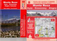
![]() | 8 Monte Rosa - Ayas - Gressoney - Alagna 1:25.000 (wasserfest) Topographische Wanderkarte l`Escursionista Editore - Italien |
![]() | Armenien - Aserbaidschan 1:430.000 (wasserfest) Landkarte - ITMB International Travel Maps (engl.) Armenija - Azerbaijan |
![]() | 3816OT Strasbourg Topographische Wanderkarte Frankreich 1:25.000 TOP 25 IGN - (GPS) |
![]() | 2640-SW Topographische Karte 1:10.000 - Landesvermessungsamt Brandenburg |
![]() | 7 Val Pellice (GPS-tauglich) Topographische Wanderkarte und Straßenkarte 1:25.000 Fraternali Editore - Italien |
![]() | 2738SB Le Bleymard - la Bastide-Puylaurent - GPS Amtliche Topographische Wanderkarte Frankreich 1:25.000 - série bleue (IGN) |
![]() | 326 Ayr & Troon - Wanderkarte Großbritannien 1:25.000 EXPLORER MAP - Ordnance Survey |
![]() | Norwegen - Straßenkarte Nordnorwegen Nord 1:500.000 Veikart Nord-Norge Nord Nordeca / UglandIT / Statens Kartverk - Norwegen |
![]() | 2524SB Nevers / Jouet-sur-lAubois GPS Amtliche Topographische Wanderkarte Frankreich 1:25.000 - série bleue (IGN) |
![]() | 221 Coventry & Warwick - Royal Leamington Spa & Kenilworth - Wanderkarte Großbritannien 1:25.000 EXPLORER MAP - Ordnance Survey |
![]() | Gebrauchsanweisung für Portugal - von Eckhart Nickel - Piper Verlag |
![]() | 233.23 Amtliche topographische Karte 1:25.000 Polen |
![]() | N-34-130-C/D Siemiatycze Amtliche topographische Landkarte Polen 1:50.000 N-34-130-C/D Siemiatycze - Mapa Topograficzna Polski Glowny Geodeta Kraju |
![]() | 68 Mährische Pforte - Odergebirge Wanderkarte Tschechien 1:50.000 Moravská Brana - Oderské vrchy - SHOCart |
![]() | 8240 Marquartstein Topographische Landkarte Bayern 1:25.000 - Normalausgabe - ProjektNord (geplottete Ausgabe) - Grundlage amtliche Topographische Karte Bayern DTK25 |
![]() | 1742 O EAUZE GPS Amtliche Topographische Wanderkarte Frankreich 1:25.000 - série bleue (IGN) |
![]() | N5124 Joroinen Topographische Karte 1:25.000 EUREF (Peruskartta) Maanmittauslaitos / Lantmäteriverket Finnland - ProjektNord |
![]() | Dartmoor - South: Ivybridge and Princetown - 15 short walks Wanderführer - Cicerone (englisch) |
![]() | 32 Ceské Budejovice Topographische Karte 1:200.000 der Tschechischen Republik Zakladnà mapa Ceská republika - Cesky urad zememericky a katastralni - ProjektNord |
![]() | 2726SB Bourbon-Lancy - Grury GPS Amtliche Topographische Wanderkarte Frankreich 1:25.000 - série bleue (IGN) |


