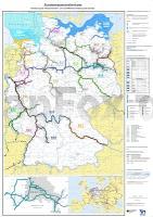
| << Deutschland: Wassersportkarten, Wassersportatlanten und Wassersportführer |
  | |
Zuletzt angesehene Artikel:
![]() | Bundeswasserstraßenkarte 1:1 Mio. (gefaltet - aktuelle Ausgabe) Gliederung der Wasserstraßen- und Schifffahrtsverwaltung des Bundes - Bundesministerium für Digitales und Verkehr |
![]() | 5527 Mellrichstadt Topographische Landkarte Bayern 1:25.000 - Normalausgabe - ProjektNord (geplottete Ausgabe) - Grundlage amtliche Topographische Karte Bayern DTK25 |
![]() | Nationalpark Tara 1:50.000 - Serbien Topographische Wanderkarte Национални парк Тара (Србија) ProjektNord |
![]() | Woiwodschaft Pommern - Naturschutz - Naturkarte - pädagogische Karte 1:220.000 (Blatt 498) Ochrona przyrody w Województwie Pomorskim - mapa edukacyjna Cartomedia - Sygnatura Polen |
![]() | Habelschwerdter Gebirge und Adlergebirge Touristische Landkarte 1:35.000 Wanderkarte, Radwanderkarte, Freizeitkarte, Wintersportkarte Góry Bystrzyckie i Góry Orlickie (wyd. pap.) Compass - Polen |
![]() | 1196 Aulenbach (Ostpreußen) Topographische Karte 1:25.000 Messtischblatt des Deutschen Reiches - Preußische Landesaufnahme / Reichsamt für Landesaufnahme - Faksimile ProjektNord |
![]() | 2412-I Skælskør - mit Wanderwegen und Fahrradrouten Topographische Fahrradkarte und Wanderkarte Dänemark 1:50.000 - Kort & Matrikelstyrelsen ProjektNord 2412-I Skælskør - Topografisk Cykel- og Vandrekort Danmark |
![]() | 7/8: Kiew und Umgebung - Borispil - Perejaslaw - Chmelnizkij Topographische Wanderkarte 1:50.000 - Ukraine Київ та околиці №7/8 Бориспіль/Переяслав-Хмельницький ukrmap Kartografija |
![]() | Lillehammer - Rena - Nordseter - Sjursjøen - Hafjell - Øyer - Hornsjø - Åstdalen - Goppollen Topographische Wanderkarte Topo 3000 - 1:50.000 (Blatt 3008) - Nordeca - Norwegen |
![]() | 7230 Donauwörth Topographische Landkarte Bayern 1:25.000 - Normalausgabe - ProjektNord (geplottete Ausgabe) - Grundlage amtliche Topographische Karte Bayern DTK25 |
![]() | 15: Otago - South Canterbury - Topographische Straßenkarte 1:250.000 - Neuseeland (Blatt 250-15) Landkarte Timaru - Oamaru - Wanaka - Alexandra - Mit New Zealand Cycle Trails Otago - South Canterbury - Rural Road Map 1:250 Series Map 15 of 18 Kiwimaps Ltd - Neuseeland |
![]() | Schlesien (Woiwodschaft) 1:150.000 Straßenkarte / Landkarte mit administrativen Grenzen WOJEWODZTWO SLASKIE - mapa samochodowa z podzialem administracyjnym Wydawnictwo Pietka - Polen |
![]() | 1023 09 Porsskär Topographische Karte 1:20.000 (Maastokartta / Peruskartta / Grundkarta) Maanmittauslaitos / Lantmäteriverket Finnland - ProjektNord |
![]() | Nördliches Ostpreussen - Königsberger Gebiet und Memelland Königsberger Gebiet und Memelland - Ortsnamenverzeichnis und Karte - deutsch-russisch und deutsch-litauisch - Rautenberg |
![]() | Iwanowo Stadtplan 1:20.000 - Russland Иваново - Карта города Rus Co. Ltd. |
![]() | 2224 02 Kaulalamminneva Topographische Karte 1:20.000 (Maastokartta / Peruskartta / Grundkarta) Maanmittauslaitos / Lantmäteriverket Finnland - ProjektNord |
![]() | 3 Bajanchongor Aimag 1:600.000 Touristische Landkarte Bayanhongor Aymag - Баянхонгор аймaг газрын зураг - Монсудар Monsudar - Mongolei |
![]() | 0869 JUMILLA Topographische Landkarte 1:50.000 Spanien (Grundlage MTN50) Instituto Geográfico Nacional - CNIG Spanien - ProjektNord |
![]() | Storfjorden - Ytre del med Hjørundfjorden - Seekarte Norwegische Küste 1:50.000 - (Blatt 127) Den Norske Kyst Sjøkart - Hovedkart (sjø) Statens Kartverk Sjø - Norwegen |
![]() | 6237 Grafenwöhr Topographische Landkarte Bayern 1:25.000 - Normalausgabe - ProjektNord (geplottete Ausgabe) - Grundlage amtliche Topographische Karte Bayern DTK25 |


