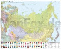
| << Russland << Asien: Wandkarten und Poster |
  | |
Zuletzt angesehene Artikel:
![]() | Russland und Nachbarländer (engl.) 1:8 Mio. POSTER LAMINIERT 109 x 86 cm Russia and Neighbouring Countries |
![]() | DuMont direkt Lago Maggiore *** SCHNÄPPCHEN *** von Lonmon, Aylie |
![]() | 5214 Burbach (geplottete Ausgabe) Amtliche topographische Karte 1:25.000 Landesvermessungsamt Nordrhein-Westfalen |
![]() | 0201-1 MONASTERIO DE RODILLA Topographische Landkarte 1:25.000 Spanien (Grundlage MTN25) Instituto Geográfico Nacional - CNIG Spanien - ProjektNord |
![]() | Bonn - Ville Topographische Wanderkarte Nordrhein-Westfalen mit Wanderwegen und Radwegen 1:25.000 - ProjektNord |
![]() | 8242 Inzell Topographische Landkarte Bayern 1:25.000 - Normalausgabe - ProjektNord (geplottete Ausgabe) - Grundlage amtliche Topographische Karte Bayern DTK25 |
![]() | 3849 Alt-Schadow Sonderausgabe mit Wanderwegen - Topographische Wanderkarte Brandenburg 1:25.000 ProjektNord |
![]() | 2649 Prenzlau Sonderausgabe mit Wanderwegen - Topographische Wanderkarte Brandenburg 1:25.000 ProjektNord |
![]() | Balkanbeat Meine Suche nach Patrick Leigh Fermor - von Michael Obert - Malik National Geographic |
![]() | 4105 Bocholt (geplottete Ausgabe) Amtliche topographische Karte 1:25.000 Landesvermessungsamt Nordrhein-Westfalen |
![]() | 2547 Woldegk Sonderausgabe mit Wanderwegen - Topographische Wanderkarte Brandenburg 1:25.000 ProjektNord |
![]() | Wolgograder Oblast Topografischer Regional-Atlas 1:200.000 Volgogradskaja oblastj - topografitscheskaja Karta - Russland |
![]() | 0246-3 FARASDUÉS Topographische Landkarte 1:25.000 Spanien (Grundlage MTN25) Instituto Geográfico Nacional - CNIG Spanien - ProjektNord |
![]() | 437 Ben Wyvis & Strathpeffer - Wanderkarte Großbritannien 1:25.000 EXPLORER MAP - Ordnance Survey |
![]() | 232 (13-11) Villamañan Amtliche topographische Landkarte 1:50.000 Spanien (M.T.N.) 232 Mapa Topográfico Nacional de Espana (MTN50) Instituto Geográfico Nacional - CNIG Spanien |
![]() | 5604 Hallschlag - Wanderkarte mit Wanderwegen (geplottete Ausgabe) ProjektNord - Grundlage Amtliche topographische Karte Landesamt für Vermessung und Geobasisinformation Rheinland-Pfalz |
![]() | 0804-2 MANCHITA Topographische Landkarte 1:25.000 Spanien (Grundlage MTN25) Instituto Geográfico Nacional - CNIG Spanien - ProjektNord |
![]() | 803-4 PALACIO QUEMADO Amtliche topographische Landkarte 1:25.000 Spanien (M.T.N.) 803-4 Mapa Topográfico Nacional de Espana (MTN25) Instituto Geográfico Nacional - CNIG Spanien |
![]() | Vesdre - Hoëgne GR573 Helle et Haute Fagnes Topo-Guide du Sentier de Grande Randonnée - Belgien (französisch) GRSentiers |
![]() | Julische Alpen - Alpi Giulie 1:25.000 (Blatt 064) *** SCHNÄPPCHEN *** 3in1 Wanderkarte 1:25000 mit Aktiv Guide inklusive Karte zur offline Verwendung in der KOMPASS-App. Fahrradfahren. Skitouren. Langlaufen. - von KOMPASS-Karten GmbH |


