Willkommen bei MapFox
Wurde Ihre Bestellung bestätigt? Wenn nicht - gab es evtl. ein SERVER-Problem! Bitte kontaktieren Sie uns! +++ Buchhändler-Anfragen erwünscht +++
Warenkorb
Artikel: 0 - € 0.00
Zur Kasse
Widerruf Impressum Kontakt Versandkosten AGB
Estland Straßenatlas 1:100.000 (estnisch/englisch/finnisch/russisch)
Eesti Teedeatlas REGIO Estland
<< Estland
<< Regio Ltd. Estland
 
Cover

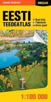
Sehr detaillierter Straßenatlas von Estland. Mit Stadtplänen und Ortsregister.

Atlas 96 pages, clamp binding, dimensions 30 x 30 cm. Travel guide/name index 104 pages, clamp binding, dimensions 15 x 30 cm. Scale 1:100.000

Legend in 4 languages: Estonian, Finnish, English, Russian
Atlas plus guidebook/place name index are packed into a plastic holder

Regio Estonian Road Atlas (Regio Eesti teedeatlas) has been the best sold road atlas in Estonia for many years and has become an icon among its kind. In addition to maps, the atlas contains a lot of practical travel tips - travel guide, information on airports, ports and bus stations etc. The atlas comes with a free app for iOS and Android smartphones.

The new Regio Estonian Road Atlas is dedicated to the 100th anniversary of the Republic of Estonia. The historic sites relating to Estonian independence are therefore highlighted in the atlas.

Inside the atlas:

The most accurate Estonian map available, scale 1:100.000,
- Maps of major cities.
- About 300 historic sites relating to Estonian independence. Historian Mart Laar selected the sites and wrote information about them.
- 100 objects from The Estonian National Heritage Board adventure game ´100 treasures of Estonia´
- 4700 places of interest
- 1260 natural sights
- 675 manors
- 560 museums, workshops and theme parks
- 410 nature and hiking trails
- 485 churches
- Distance matrix of Estonian towns
- Index of locations

Kartenausschnitt

Kartenbeispiel

Estland Straßenatlas 1:100.000 (estnisch/englisch/finnisch/russisch)
Eesti Teedeatlas REGIO Estland
EAN / ISBN: 9789916700020
Preis: EUR 39.90

sofort versandfertig Dieser Artikel ist im Normalfall sofort lieferbar.
Produkt EUR Anzahl Bestellen
Estland Straßenatlas 1:100.000 (estnisch/englisch/finnisch/russisch)
Eesti Teedeatlas REGIO Estland
39.90
Versandkostenfrei in Deutschland

incl. MwSt.

Stichworte, die bei der Suche nützlich sein könnten:
Estland Autoatlas - Estland - Jogeva - Dagö - Jogevamaa - Estonia road atlas - Kopu Poolsaar - Tartu - Tallinn - Viljandi - Otepää Ümbrus - Piusa - Pärnu - Estland Straßenatlas - Rakvere - Estland - Eesti - Estonia - Estland Straßenkarten - Estland Autokarten - Estland Fahrradkarten - Estland Autoatlanten - Estland Straßenatlanten - Landkarten aus Estland - Estland Landkarten - Estonia maps - Estland Reiseführer - Estlandkarten - estnische Landkarten - Estonian maps - Estland Karten - Regio Ltd. - Regi Verlag Estland - Estland - Estonia - Eesti - Estland Landkarten - Estonia maps - Eesti - Estnische Lankarten

Zuletzt angesehene Artikel:

CoverEstland Straßenatlas 1:100.000 (estnisch/englisch/finnisch/russisch)
Eesti Teedeatlas REGIO Estland

Cover151 Stratford-upon-Avon - Warwick & Banbury - Wanderkarte Großbritannien 1:50.000 LANDRANGER MAP - Ordnance Survey

CoverKarstwanderweg Südharz - Leporello 1:33.000 wetterfest Wanderkarte Harz KKV - Kartographische Kommunale Verlagsgesellschaft

Cover60/1-2 LA-ROCHE-EN-ARDENNE NGI 1:25.000 *** SCHNÄPPCHEN *** Topographische Landkarte Belgien

CoverPorto Pocket Guide Reiseführer Lonely Planet (engl.)

Cover309 Stranraer & The Rhins - Wanderkarte Großbritannien 1:25.000 EXPLORER MAP - Ordnance Survey

CoverF512 Freizeitkarte Unteres Taubertal - Tauberbischofsheim 1:50.000 - Landesvermessungsamt Baden-Württemberg

Cover20C MARKERMEER Topographische Karte der Niederlande 1:25.000 (Plotausgabe)
20C MARKERMEER Topografische Kaart van Nederland Kadaster - ProjektNord

Cover49G HOOGERHEIDE Topographische Karte der Niederlande 1:25.000 (Plotausgabe)
49G HOOGERHEIDE Topografische Kaart van Nederland Kadaster - ProjektNord

Cover8123 Weingarten Topographische Landkarte 1:25.000 - Landesvermessungsamt Baden-Württemberg

Cover21a Insel Cres - Wanderkarte 1:25.000 / 1:75.000 Tramontana - Beli - Porozine - Krizici - Sis 639 m - Lubenice - Helm 482 m - Martinscica - Merag - Cres - V. Graciste 562 m
Otok Cres Planinarska Karta Smand Kroatien

Cover50D ULLCOTEN Topographische Karte der Niederlande 1:25.000 (Plotausgabe)
50D ULLCOTEN Topografische Kaart van Nederland Kadaster - ProjektNord

Noch kein Cover vorhanden079 S Rondane SØR 1:50.000 - Amtliche Topographische Landkarte Norwegen - Startens Kartverk

CoverToskana Straßenkarte 1:250.000 Straßenkarte
Toscana Carta Stradale L.A.C. GlobalMap Italien