Willkommen bei MapFox
Wurde Ihre Bestellung bestätigt? Wenn nicht - gab es evtl. ein SERVER-Problem! Bitte kontaktieren Sie uns! +++ Buchhändler-Anfragen erwünscht +++
Warenkorb
Artikel: 0 - € 0.00
Zur Kasse
Impressum Kontakt Versandkosten AGB
Syunik Legends - Trail Hiking Guidebook A 15-day, 154 km hiking itinerary through southern Armenia - Cartisan
<< Armenien und Bergkarabach
<< Cartisan - Landkarten und Wanderführer Armenien
 
Cover

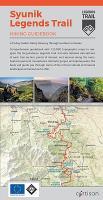
A comprehensive guidebook with 1:25.000 topographic maps to navigate the long-distance Legends Trail. Includes detailed descriptions of each trail section, points of interest and services along the route. Featuring ancient monasteries, dramatic gorges, and alpine peaks, this book will guide you through some of the richest cultural and natural landscapes Armenia has to offer.

96 Seiten

Kartenausschnitt

Kartenbeispiel

Syunik Legends - Trail Hiking Guidebook A 15-day, 154 km hiking itinerary through southern Armenia - Cartisan
EAN / ISBN: 9789939919829
Preis: EUR 14.90

Fehlt kurzfristig am Lager. - Versandfertig in ca. 2 Wochen oder länger.
Produkt EUR Anzahl Bestellen
Syunik Legends - Trail Hiking Guidebook A 15-day, 154 km hiking itinerary through southern Armenia - Cartisan 14.90
Versandkostenfrei in Deutschland ab 30,- Bestellwert

incl. MwSt.

Stichworte, die bei der Suche nützlich sein könnten:
Gomk - Kapuyt - Caucasus - Kaukasus Wanderkarte - Armenien - Armenia - Vayots Dzor - Transcaucasian Trail - Legends Trail - Armenien - Bergkarabach - Cartisan - Armenien - Bergkarabach - Nagorni Karabagh

Zuletzt angesehene Artikel:

CoverSyunik Legends - Trail Hiking Guidebook A 15-day, 154 km hiking itinerary through southern Armenia - Cartisan

CoverPI13 Manuae (Cookinseln) Topographische Landkarte 1:25.000 - Land Information New Zealand

CoverBrittany Coast Path - GR34 Mont Saint-Michel to Roscoff Wanderführer - Cicerone (englisch)

CoverPI05 Pukapuka (Cookinseln) Topographische Landkarte 1:25.000 - Land Information New Zealand

CoverPI15 Atiu (Cookinseln) Topographische Landkarte 1:25.000 - Land Information New Zealand

CoverPI01 Atafu (Tokelau-Inseln) Topographische Landkarte 1:25.000 - Land Information New Zealand

CoverOL56 Badenoch & Upper Strathspey - Wanderkarte Großbritannien 1:25.000 EXPLORER MAP - Ordnance Survey

CoverCalifornia Mission Trails - From Sonoma to San Diego Wanderführer - Cicerone (englisch)

CoverGroßglockner Hochalpenstraße Die schönsten Wanderungen und Bergtouren. 55 Touren. Mit GPS-Daten - von Walter Mair - Bergverlag Rother

Cover2103 Hochkönig 1:25.000 - Wanderkarte Österreich - GPS - Freytag & Berndt