Willkommen bei MapFox
Wurde Ihre Bestellung bestätigt? Wenn nicht - gab es evtl. ein SERVER-Problem! Bitte kontaktieren Sie uns! +++ Buchhändler-Anfragen erwünscht +++
Warenkorb
Artikel: 0 - € 0.00
Zur Kasse
Impressum Kontakt Versandkosten AGB
Finland 360° The most beautiful places and sights - Bildband Karttakeskus - Genimap Finnland
<< Finnland
<< Genimap / Karttakeskus Finnland
 
Cover

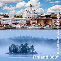
Photo journey through Finland

Finland 360 - The most beautiful places and sights, presents our beautiful homeland with pictures and captions. Finland is presented by regions. The journey begins from Åland in the south and ends up north to Lapland. The book shows the change from spring to summer and from the colors of the autumn to the early winter grayness and finally to the glory of the snow. The reader will be able to locate the places on the book from the region maps.

The book`s attractions are the most beautiful Finland, cultural and natural sights. There is also a glimpse of the Finnish lifestyle, and everyday life. Captions on the pictures are in English. In the end of the book you will find the same captions translated to other languages (Finnish, Swedish, German, French, Russian, Spanish, Japanese and Chinese).

The book is a beautiful gift to take abroad, be given to partners and a souvenir for tourists. Or just for your personal enjoyment.

Size 16.5 x16, 5 cm 144 pages

Kartenbeispiel

Finland 360° The most beautiful places and sights - Bildband Karttakeskus - Genimap Finnland
EAN / ISBN: 9789522665294
Preis: EUR 29.90

Bestellartikel: versandfertig in ca. 2 Wochen oder länger. Dieser Artikel wird speziell für Sie bestellt. Keine Rücknahme!
Produkt EUR Anzahl Bestellen
Finland 360° The most beautiful places and sights - Bildband Karttakeskus - Genimap Finnland 29.90
Versandkostenfrei in Deutschland ab 30,- Bestellwert

incl. MwSt.

Stichworte, die bei der Suche nützlich sein könnten:
Finnland - Finnland Bildband - Finland 360° Bildband - Genimap Landkarten - Karttakeskus Landkarten - Finnland Landkarten - Finnlandkarten - Finnische Landkarten - Finnland Wanderkarten - Suomi - Finnland Landkarten - Finnland Reiseführer - finnische Landkarten - Finnlandkarten - finnish maps - Finnland Straßenkarten - Finnland Wanderkarten - Finnland Autokarten - Finnland Karten

Zuletzt angesehene Artikel:

CoverFinland 360° The most beautiful places and sights - Bildband Karttakeskus - Genimap Finnland

CoverKamjanez-Podilskyj / Kamjenez-Podolski / Kamenez-Podolski Stadtplan 1:10.000
Kamianets Podils`ky Kartografija - ukrmap Ukraine

CoverL5928 Haßfurt (geplottete Ausgabe) Topographische Karte Bayern 1:50.000 Bayerisches Landesvermessungsamt

CoverGravel Bike in Vaucluse - 30 routes all levels 1:73.000 MTB-Führer (englisch) Guide VTOPO Frankreich

Cover2936 Wittenberge - Bentwisch Topographische Karte 1:25.000 Landesvermessungsamt Brandenburg (gefaltet)

CoverTourenkarten-Paket: Atlantikstraße 2 Wanderkarten Norwegen 1:50.000 (Nr. 2698)
Turkartmappe Atlanterhavsvegen - Nordeca / UGLAND / Statens Kartverk Norwegen

CoverL6932 Hilpoltstein (geplottete Ausgabe) Topographische Karte Bayern 1:50.000 Bayerisches Landesvermessungsamt

CoverJakobswegweiser Weinviertel Pilger- und Wanderführer durch die Regionen Weinviertel und Wagram - Freytag-Berndt und ARTARIA

CoverLas Marches du Velay... à pied - Réf. P43D Topographischer Wanderführer - FFRP (Fédération française de randonnée pédestre) Frankreich

Noch kein Cover vorhandenL4136 Calbe (Saale) Topographische Karte 1:50.000 Landesamt für Vermessung und Geoinformation Sachsen-Anhalt (Landesvermessungsamt)

Noch kein Cover vorhanden4135 Staßfurt Topographische Karte 1:25.000 Landesamt für Vermessung und Geoinformation Sachsen-Anhalt (Landesvermessungsamt)

Cover1304 VAL-D`ILLIEZ 1:25.000 - Champéry - Troistorrents - St-Maurice - Topographische Landeskarte der Schweiz - swisstopo

Cover4123 Stadtoldendorf Amtliche topographische Karte 1:25.000 Landesvermessungsamt Niedersachsen

CoverDibra Präfektur-Landkarte Albanien 1:100.000 GPS (Blatt 355) wasserfest Vektor Editions - Albanien

CoverParc Natural de les Capcaleres - Parc Natural del Ter i del Freser Blatt 56) 1:25.000 - Wanderkarte Katalonien (Spanien) - Col·lecció Unitats Geogràfiques - Institut Cartogràfic de Catalunya

CoverStorlien - Sylarna - Helags & Ramundberget Fjällkartan - Bergwanderkarte 1:50.000 Calazo Förlag Schweden

CoverSalomonen 1:910.000 - Südlicher Pazifischer Ozean 1:12 Mio. Landkarte - ITMB International Travel Maps (engl.)
Solomon Islands

CoverL6538 Nabburg (geplottete Ausgabe) Topographische Karte Bayern 1:50.000 Bayerisches Landesvermessungsamt

CoverBertrix NGI 1:25.000 Touristische Landkarte und Wanderkarte Belgien (fläm./frz.)

CoverCamino Santiago 27-30 GPS Triacastela - Arzúa Touristische Wanderkarte 1:50.000 - CNIG Spanien