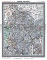
| << Historische Deutschlandkarten << Rockstuhl |
  | |
Zuletzt angesehene Artikel:
![]() | Provinz RHEINLAND - um 1903 (Reprint PLANO) - von Handtke, Friedrich (Kartograf) Rockstuhl, Harald (Mitwirkender) - Verlag Rockstuhl |
![]() | 4251-SO Topographische Karte 1:10.000 - Landesvermessungsamt Brandenburg |
![]() | 511.42 Amtliche topographische Karte 1:25.000 Polen |
![]() | N-33-71-C/D Tuchomie Amtliche topographische Landkarte Polen 1:50.000 N-33-71-C/D Tuchomie - Mapa Topograficzna Polski Glowny Geodeta Kraju |
![]() | 235.11 Amtliche topographische Karte 1:25.000 Polen |
![]() | 17 I Topographische Landkarte Portugal 1:50.000 Carta Militar de Portugal Instituto Geográfico do Exército (IGeoE) - Portugal |
![]() | Long Beach / Pacific & Wahkiakum Counties Stadtplan 1:32.000 (Washington - USA) Long Beach / Pacific & Wahkiakum Counties street map GM Johnson |
![]() | 3037-SO Topographische Karte 1:10.000 - Landesvermessungsamt Brandenburg |
![]() | 3140-NO Topographische Karte 1:10.000 - Landesvermessungsamt Brandenburg |
![]() | 233.42 Amtliche topographische Karte 1:25.000 Polen |
![]() | 233.1 Amtliche topographische Karte 1:50.000 Polen |
![]() | Taos / Los Alamos / Espanola / White Rock / Chimayo Stadtplan 1:36.000 (New Mexico - USA) Taos / Los Alamos / Espanola / White Rock / Chimayo street map GM Johnson |
![]() | 2848-NO Topographische Karte 1:10.000 - Landesvermessungsamt Brandenburg |
![]() | 246.32 Podozierany Amtliche topographische Karte 1:25.000 Polen |
![]() | 423.24 Amtliche topographische Karte 1:25.000 Polen |
![]() | 147.32 Amtliche topographische Karte 1:25.000 Polen |
![]() | 173.22 Amtliche topographische Karte 1:25.000 Polen |
![]() | 113 - Topographische Landkarte Portugal 1:25.000 Carta Militar de Portugal - Série M889 Instituto Geográfico do Exército (IGeoE) - Portugal |
![]() | 3652-NO Topographische Karte 1:10.000 - Landesvermessungsamt Brandenburg |
![]() | 3840-NW Topographische Karte 1:10.000 - Landesvermessungsamt Brandenburg |


