| << Deutschland: Historische Karten und Stadtpläne (im Bereich der heutigen Bundesrepublik) << Rockstuhl |
||
|
||

Zuletzt angesehene Artikel:
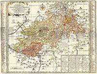
 | Vogtland - Neustädtische Kreis und die Ämter Arnshaugk, Miltenfurth, Weyda 1757 - Historische Landkarte Nachdruck Planokarte - gerollt von Schenk, Peter - Verlag Rockstuhl |
 | Östlicher Taunus (Nr. 840) - Wanderkarte mit Broschüre - 4in1 Wanderkarte 1:50000 mit Aktiv Guide und Detailkarten inklusive Karte zur offline Verwendung in der KOMPASS-App. Fahrradfahren - KOMPASS-Karten GmbH |
 | Polnische Ostseeküste Reiseführer Michael-Müller-Verlag - Reiseführer |
 | Il Devoto Cammino dei Sacri Monti 1:25.000 / 1:50.000 - dal Piemonte alla Lombardia - Topographischer Wanderführer - Geo4 Map - Italien |
 | Val d`Elsa e Val di Pesa Wanderkarte 1:50.000 Carta Turistica e dei Sentieri - Edizioni Multigraphic - Italien |
 | 4150OT PORTO - Calanche de Piana - RNR de Corse - Topographische Wanderkarte Frankreich 1:25.000 TOP 25 IGN |
 | ES03 Västervik Topographische Wanderkarte 1:50.000 - Einzelblatt Västervik - Enkelkarta, Terrängkarta UTEKARTAN - Schweden |
 | N° 5 LOT Kanalführer / Waterways Giude / Guide Fluvial - Lot navigable entre Aiguillon et Saint Vite et entre Luzech et Larnagol Wasserstraßen-Führer Frankreich - Édition du Breil |
 | Niesky (Blatt 53) Topographische Wanderkarte Sachsen 1:30.000 mit Wanderwegen - ProjektNord |