| << Nordrhein-Westfalen: Radwanderkarten und Fahrradführer << ADFC-Radtourenkarten - ADFC-Regionalkarten - BVA-Radwanderkarten - BVA-Radführer |
  | |
|
||
Zuletzt angesehene Artikel:
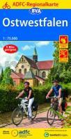
![]() | Ostwestfalen ADFC-Regionalkarte 1:75.000 BVA Bielefelder Verlag |
![]() | 3543 08 Siiranjoki Topographische Karte 1:20.000 (Maastokartta / Peruskartta / Grundkarta) Maanmittauslaitos / Lantmäteriverket Finnland - ProjektNord |
![]() | 3328 Groß Oesingen Amtliche topographische Karte 1:25.000 Landesvermessungsamt Niedersachsen |
![]() | 32 Llanes Amtliche topographische Landkarte 1:50.000 Spanien (M.T.N.) 32 Mapa Topográfico Nacional de Espana (MTN50) Instituto Geográfico Nacional - CNIG Spanien |
![]() | 3532 Rätzlingen Topographische Karte 1:25.000 Landesamt für Vermessung und Geoinformation Sachsen-Anhalt (Landesvermessungsamt) |
![]() | 30 Antwerpen Topographische Karte der Niederlande 1:100.000 (Plotausgabe) kadaster - Topografische Dienst / ProjektNord |
![]() | 3358 Trebisch Topographische Karte 1:25.000 Messtischblatt des Deutschen Reiches - Preußische Landesaufnahme / Reichsamt für Landesaufnahme - Faksimile ProjektNord |
![]() | Pembrokeshire South - Top 10 Walks Series Circular Walks along the Wales Coast Path - Dennis Kelsall - Mara Books |
![]() | 345.21 Amtliche topographische Karte 1:25.000 Polen |
![]() | 314.12 Amtliche topographische Karte 1:25.000 Polen |
![]() | 3523 02 Iso Litojärvi Topographische Karte 1:20.000 (Maastokartta / Peruskartta / Grundkarta) Maanmittauslaitos / Lantmäteriverket Finnland - ProjektNord |
![]() | Kykladen (Blatt 059) Regionale Landkarte 1:195.000 Orama - Griechenland Κυκλάδες - Cyclades |
![]() | 11 Parco Nazionale Dolomiti Bellunesi Ovest 1:30.000 Wanderkarte - LIBRERIA ZANETTI - Italien |
![]() | Pilgertouren nach Santiago de Compostela Wanderführer (schwedischsprachig) Pilgrimsturer till Santiago de Compostela Vildmarksbiblioteket Schweden |
![]() | 5049 Pirna (83) - Geologische Karte 1:25.000 (GK25) Grundlage Messtischblatttopographie Sächsisches Landesamt für Umwelt, Landwirtschaft und Geologie |
![]() | 3241 05 Suontee Topographische Karte 1:20.000 (Maastokartta / Peruskartta / Grundkarta) Maanmittauslaitos / Lantmäteriverket Finnland - ProjektNord |
![]() | 34-141 Topographische Karte 1:25.000 der Tschechischen Republik Zakladní mapa Ceská republika Cesky urad zememericky a katastralni - ProjektNord |
![]() | Porzellanland Thüringen 1:250.000 Landesvermessung und Geobasisinformation Thüringen |
![]() | 335.24 Amtliche topographische Karte 1:25.000 Polen |
![]() | 3261 Altsorge Topographische Karte 1:25.000 Messtischblatt des Deutschen Reiches - Preußische Landesaufnahme / Reichsamt für Landesaufnahme - Faksimile ProjektNord |


