Willkommen bei MapFox
Wurde Ihre Bestellung bestätigt? Wenn nicht - gab es evtl. ein SERVER-Problem! Bitte kontaktieren Sie uns! +++ Buchhändler-Anfragen erwünscht +++
Warenkorb
Artikel: 0 - € 0.00
Zur Kasse
Impressum Kontakt Versandkosten AGB
Historische WELTKARTE um 1660 - Justus Danckert (Plano 71 x 58 cm) - Historische Landkarte Titelkartusche der World Map: Nova Totius Terrarum Orbis Tabula | Weltkarten Vol. 4 - von Justus Danckert - PLANO gerollt - Verlag Rockstuhl
<< Rockstuhl
 
Cover

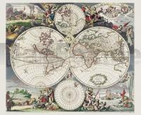
Farbenprächtiger Nachdruck, Lieferung gerollt, Blattgröße (B x H) 71 x 58 cm, Bedrucktes Blatt (B x H) 64 x 54 cm. Origilalmaßstab ca. 1:100 000 000- aber die Darstellung um 15 % vergrößert zum Original. Kartograph: Justus Danckert.

[Lieferung in einer sehr stabilen Pappversandhülse - bis 72 cm lang - 25 g]

Historische WELTKARTE um 1660 - Justus Danckert (Plano 71 x 58 cm) - Historische Landkarte Titelkartusche der World Map: Nova Totius Terrarum Orbis Tabula | Weltkarten Vol. 4 - von Justus Danckert - PLANO gerollt - Verlag Rockstuhl
EAN / ISBN: 9783867776134
Preis: EUR 24.95

sofort versandfertig Dieser Artikel ist im Normalfall sofort lieferbar.
Produkt EUR Anzahl Bestellen
Historische WELTKARTE um 1660 - Justus Danckert (Plano 71 x 58 cm) - Historische Landkarte Titelkartusche der World Map: Nova Totius Terrarum Orbis Tabula | Weltkarten Vol. 4 - von Justus Danckert - PLANO gerollt - Verlag Rockstuhl 24.95
Versandkostenfrei in Deutschland ab 30,- Bestellwert

incl. MwSt.

Stichworte, die bei der Suche nützlich sein könnten:
Weltkarte historisch - Verlag Rockstuhl - Historische Karten - Historische Landkarten - Alte Landkarten - Alte Deutschlandkarten

Zuletzt angesehene Artikel:

CoverHistorische WELTKARTE um 1660 - Justus Danckert (Plano 71 x 58 cm) - Historische Landkarte Titelkartusche der World Map: Nova Totius Terrarum Orbis Tabula | Weltkarten Vol. 4 - von Justus Danckert - PLANO gerollt - Verlag Rockstuhl

Cover2315-II-SV Topographische Karte Dänemark 1:25.000
Topografisk kort Danmark (DTK/Kort25) 2315-II-SV ProjektNord - Kort & Matrikelstyrelsen / Geodætisk Institut

Noch kein Cover vorhandenRypin Topographische Karte 1:25.000 Messtischblatt des Deutschen Reiches - Preußische Landesaufnahme / Reichsamt für Landesaufnahme - Faksimile ProjektNord

Cover2113-IV-NV - Nørre Nebel Topographische Karte Dänemark 1:25.000
Topografisk kort Danmark (DTK/Kort25) 2113-IV-NV ProjektNord - Kort & Matrikelstyrelsen / Geodætisk Institut

Cover01-443 Topographische Karte 1:25.000 der Tschechischen Republik
Zakladní mapa Ceská republika Cesky urad zememericky a katastralni - ProjektNord

CoverAmt Freyburg, 1754 - Historische Landkarte Nachdruck Planokarte - gerollt von Schenk, Peter - Verlag Rockstuhl

Cover3037 Bad Wilsnack *** SCHNÄPPCHEN *** Sonderausgabe mit Wanderwegen - Topographische Wanderkarte Brandenburg 1:25.000 ProjektNord

Cover0286-4 NOVALES Topographische Landkarte 1:25.000 Spanien (Grundlage MTN25) Instituto Geográfico Nacional - CNIG Spanien - ProjektNord