Willkommen bei MapFox
Wurde Ihre Bestellung bestätigt? Wenn nicht - gab es evtl. ein SERVER-Problem! Bitte kontaktieren Sie uns! +++ Buchhändler-Anfragen erwünscht +++
Warenkorb
Artikel: 0 - € 0.00
Zur Kasse
Impressum Kontakt Versandkosten AGB
Trekking in the Moroccan Atlas Reiseführer englisch Trailblazer
Moroccan Atlas: The Trekking Guide
<< Marokko
<< Trailblazer Guides
 
Cover

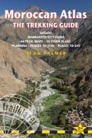
Stretching 2000 km (1200 miles) from the Atlantic port of Agadir east to Tunisia the Atlas form one of the world`s great trekking ranges.   The High Atlas region in central Morocco is the most dramatic and beautiful section of the entire range.  Towering peaks, deep gorges and huddled Berber villages enchant all who visit.

  • 44 detailed trekking maps - showing route times, places to stay and points of interest. The best treks in: Toubkal, Sirwa, Sahro, Mgoun
  • Practical information - planning your trip and getting to Morocco from Europe, North America and Australasia
  • Cultural and historical background - customs, religion, art, cuisine
  • Town guides and maps - Marrakech, Ouarzazate, Imlil, Azilal, Tabant, Taliwine, Nkoub, Qalaa`t Mgouna and Boumalne du Dades  showing street plans, where to stay, where to eat, what to see and how to get to the start of your trek
  • Green hiking and mountain safety - how to stay healthy on your trek and minimise your impact on a fragile region
  • Language sections - Arabic, Berber and French
  • Atlas flora and fauna - with an illustrated bird identification section

Kartenausschnitt

Kartenbeispiel

Trekking in the Moroccan Atlas Reiseführer englisch Trailblazer
Moroccan Atlas: The Trekking Guide
EAN / ISBN: 9781905864591
Preis: EUR 23.50

Bestellartikel: versandfertig in ca. 3-7 Tagen. Dieser Artikel wird speziell für Sie bestellt. Keine Rücknahme!
Produkt EUR Anzahl Bestellen
Trekking in the Moroccan Atlas Reiseführer englisch Trailblazer
Moroccan Atlas: The Trekking Guide
23.50
Versandkostenfrei in Deutschland ab 30,- Bestellwert

incl. MwSt.

Stichworte, die bei der Suche nützlich sein könnten:
Sirwa - Atlas Mountains - Toubkal - Mgoun - Atlas-Gebirge - Marokko Atlasgebirge - Morocco Atlas Trekking - Sahro - Marokko - Marokko Straßenkarten - Marokko Atlanten - Marokko Wanderkarten - Marokko Karten - Marokko Fahrradkarten - Marokkokarten - Marokko Kartografie - Marokko Radwanderführer - Marokko Kartographie - Marokko Radwanderkarten - Marokko Reiseführer - Marokko Landkarten - Marokko Landkartenverkauf - Morocco - Morocco maps - Trailblazer

Zuletzt angesehene Artikel:

CoverTrekking in the Moroccan Atlas Reiseführer englisch Trailblazer
Moroccan Atlas: The Trekking Guide

CoverNördliches Ostpreussen - Königsberger Gebiet In 27 deutschen topographischen Karten mit russischen Ortsnamen. Ein Atlas. Bearbeitet v. Fritz R. Barran - Rautenberg

Cover13/7-8 Zomergem NGI 1:25.000 Topographische Landkarte Belgien

Cover140 Iglau Fahrradkarte Tschechien 1:60.000
Jihlavsko - SHOCart

CoverMuraner Plateau - Stolica-Berge - Veporské vrchy (Blatt 5014) 1:50.000 Wanderkarte (slowakische Ausgabe)
Muránska planina, Stolické a Veporské vrchy TatraPlan - Slowakei

Cover5516 Weilmünster Topographische Landkarte Hessen 1:25.000 - ProjektNord (geplottete Ausgabe)

CoverK09 Rain mit Wellheim, Oberhausen, Burgheim, Tagmersheim, Marxheim, Rennertshofen ATK25 Topographische Karte 1:25.000 (Atkis) Bayern Landesvermessungsamt Bayern

CoverN-33-79/80 Gryfice Plot aus der Kartengrundlage der amtliche topographische Karte Polen 1:100.000 ProjektNord

Cover2111 04 Virkasuo Topographische Karte 1:20.000 (Maastokartta / Peruskartta / Grundkarta) Maanmittauslaitos / Lantmäteriverket Finnland - ProjektNord

CoverSüdschwarzwald 1:70.000 (Nr. 3332) Fahrradkarte - reiß- und wetterfest mit Extra Stadtplänen - von KOMPASS-Karten GmbH

Cover3335ET LE BOURG-D`OISANS Topographische Wanderkarte Frankreich 1:25.000 TOP 25 IGN - (GPS)

Cover4450 Senftenberg Sonderausgabe mit Wanderwegen - Topographische Wanderkarte Brandenburg 1:25.000 ProjektNord

Cover4514 Möhnesee (geplottete Ausgabe) Amtliche topographische Karte 1:25.000 Landesvermessungsamt Nordrhein-Westfalen

Cover4212 02 Hevonlahti Topographische Karte 1:20.000 (Maastokartta / Peruskartta / Grundkarta) Maanmittauslaitos / Lantmäteriverket Finnland - ProjektNord

Cover1421SB SEGRE - CANDE GPS Amtliche Topographische Wanderkarte Frankreich 1:25.000 - série bleue (IGN)

Cover247S SARDONA 1:50.000 - Elm - Flims - Pizol - Topographische Skitourenkarte SSV der Schweiz - swisstopo

CoverCykelkartan Blad 30 Siljan runt Fahrradkarte Schweden 1:90.000 - Norstedts

CoverFrankreich einseitig Straßenkarte 1:1 Mio. (Blatt 721) Michelin

Cover137 Tabor Fahrradkarte Tschechien 1:60.000
Táborsko - SHOCart

CoverDorset go slow Reiseführer (englisch) Bradt Publications