Willkommen bei MapFox
+++ Buchhändleranfragen willkommen! Tel. 0431-666 75 99 +++
Warenkorb
Artikel: 0 - € 0.00
Zur Kasse
Impressum Kontakt Versandkosten AGB
Explore Aviemore - Wanderkarte Visitor Map - Footprint Maps - Stirling Surveys
<< Großbritannien: Wanderkarten, Radwanderkarten und MTB-Karten
<< Stirling Surveys - Footprint Maps
 
Cover

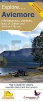
This specially produced double sided waterproof map & guide shows all the paths, tracks and trails for anyone wanting to get outside and explore this popular part of the Cairngorms National Park. The map also shows lots of other useful information for when you`re out and about; from where to get a bite to eat, to hiring or repairing your bike, way-marked trails and finding out where the steep hills are.

Use the main map to plan your own route or use the individual maps on side 2 to follow one of the suggested routes which have been carefully selected to take in some the best trails and views in the area.

Kartenausschnitt

Explore Aviemore - Wanderkarte Visitor Map - Footprint Maps - Stirling Surveys
EAN / ISBN: 9781871149890
Preis: EUR 15.90

Bestellartikel: versandfertig in ca. 1-3 Wochen. Dieser Artikel wird speziell für Sie bestellt. Keine Rücknahme!
Produkt EUR Anzahl Bestellen
Explore Aviemore - Wanderkarte Visitor Map - Footprint Maps - Stirling Surveys 15.90
Versandkostenfrei in Deutschland ab 30,- Bestellwert

incl. MwSt.

Stichworte, die bei der Suche nützlich sein könnten:
Aviemore Wanderkarte - Großbritannien Wanderkarte - Großbritannien Wanderkarten - Großbritannien Fahrradkarten - Großbritannien Mountainbike-Karten - Schottland Wanderkarten - Großbritannien Wanderkarten - Stirling Surveys - Footprint Maps - UK Hiking maps - Great Britain walking maps

Zuletzt angesehene Artikel:

CoverExplore Aviemore - Wanderkarte Visitor Map - Footprint Maps - Stirling Surveys

CoverRheinSteig NaturTOUREN Start-Set. Buch mit topografischer Wanderkarte ideemedia

CoverWestalpen Motorrad-Touren Denzel Verlag

CoverBarcelona Stadtplan 1:20.000 Mini comfort!map wasserfest - laminiert - ExpressMap

CoverMarokko 3 in 1 - Explore Guide + Atlas + Map (französisch) wasserfest - laminiert
Maroc, Morocco ExpressMap

CoverToulouse Stadtplan 1:16.500 Mini comfort!map wasserfest - laminiert - ExpressMap

CoverAustin (Texas) - Georgetown - Round Rock Stadtplan - Rand McNally - USA

CoverRothaarsteig - von Brilon nach Dillenburg Wanderführer - von Amrei Risse - Conrad Stein Verlag GmbH

CoverDenver Street Map - CO Stadtplan - Rand McNally - USA

CoverSeattle 1:10.000 Stadtplan Borch laminiert

CoverCondor Circuit 1:50.000 Trekkingkarte
Condor Circuit Trekking Map Viachile Editores - Chile

Noch kein Cover vorhandenSeattle WA City Map Stadtplan USA Rand McNally

CoverMuszyna Stadtplan 1:12 500
Muszyna plan miasta Rewasz - Polen