Willkommen bei MapFox
+++ Buchhändleranfragen willkommen! Tel. 0431-666 75 99 +++
Warenkorb
Artikel: 0 - € 0.00
Zur Kasse
Impressum Kontakt Versandkosten AGB
Cotswolds Reisekarte 1:126.720 Touring map & travel guides - Goldeneye mapguides (engl.)
Cotswolds touring mapguide Goldeneye Publications - Großbritannien
<< Großbritannien
<< Goldeneye Publications - Großbritannien
 
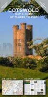
Cover

Very practical maps: on one side you will find a durable easy to use touring map. Printed overleaf you will find a comprehensive guide to all the must see attractions in the area illustrated with beautiful full colour photographs. Unusually the guide includes all the opening times. You will also find information on the top pubs, gastro pubs, hotels, galleries and museums. These maps are published without sponsorship or advertising which means that all the listings are included because we think they are worth a visit.

Kartenausschnitt

Kartenbeispiel

Cotswolds Reisekarte 1:126.720 Touring map & travel guides - Goldeneye mapguides (engl.)
Cotswolds touring mapguide Goldeneye Publications - Großbritannien
EAN / ISBN: 9781859652893
Preis: EUR 14.90

Dieser Titel ist momentan nicht lieferbar.
Produkt EUR Anzahl Bestellen
Cotswolds Reisekarte 1:126.720 Touring map & travel guides - Goldeneye mapguides (engl.)
Cotswolds touring mapguide Goldeneye Publications - Großbritannien
14.90
Versandkostenfrei in Deutschland ab 20,- Bestellwert

incl. MwSt.

Stichworte, die bei der Suche nützlich sein könnten:
Cotswolds Landkarte - Goldeneye Publications - Großbritannien Wanderkarten - Großbritannien Landkarten - Großbritannien Wanderführer - Großbritannien Reiseführer - Großbritannien - UK - United Kingdom - England - Großbritannien - UK Landkarten - England - Schottland - Wales - Nordirland - Vereinigtes Königreich - Großbritannien Karten - Großbritannien Landkarten - Großbritannien Fahrradkarten - Großbritannien Kartographie - Großbritannien Kartografie - Großbritannien Landkartenverkauf - Großbritannien Wanderkarten - Großbritannien Straßenkarten - Großbritannien Radwanderführer - Großbritannienkarten - Großbritannien Reiseführer - Großbritannien Radwanderkarten - Großbritannien Atlanten

Zuletzt angesehene Artikel:

CoverCotswolds Reisekarte 1:126.720 Touring map & travel guides - Goldeneye mapguides (engl.)
Cotswolds touring mapguide Goldeneye Publications - Großbritannien

Cover234T WILLISAU - Langethal - Napf - Sursee 1:50.000 *** SCHNÄPPCHEN *** Topographische Wanderkarte SAW der Schweiz - swisstopo

Cover5364 Hinterer Bregenzerwald - Kleines Walsertal - Damüls 1:35.000 - Wanderkarte / Radwanderkarte / Wintersportkarte Österreich - GPS - Freytag & Berndt

CoverFolyMaps Tourenkarten Set ALPEN Österreich Schweiz 1:300.000 - Biker Betten Motorradkarten Tourenkarten Set - Touristik-Verlag Vellmar

Noch kein Cover vorhandenCaravan & Camping Großbritannien (aktuelle Jahresausgabe)
Caravan & Camping Britain AA - Automobile Association

CoverMorbihan à pied 45 promenades & randonnées *** SCHNÄPPCHEN *** - Réf. D056 Topographischer Wanderführer - FFRP (Fédération française de randonnée pédestre) Frankreich

CoverDänemark - Fahrradtourenbuch 180 beliebteste Radwege
Cykelruter i Danmark - 180 mest populære cykelruter Routiq Falk - Belgien

Cover258T BERGÜN / BRAVUOGN - Surses - Albula - Flüela 1:50.000 *** SCHNÄPPCHEN *** Topographische Wanderkarte SAW der Schweiz - swisstopo

Noch kein Cover vorhandenBed & Breakfast Atlas Großbritannien (aktuelle Jahresausgabe)
Bed & Breakfast Britain AA - Automobile Association

CoverDänische Inseln 2: Møn, Falster, Lolland Reiseführer Alexander Geh - Edition Elch

CoverBrisbane & Region Handy Stadtplan *** SCHNÄPPCHEN *** 1:15.000, Vororte 1:100.000, Region 1:350.000 - HEMA Maps - Australien

CoverHautes Alpes à pied 41 promenades & randonnées PR TopoGuides *** SCHNÄPPCHEN *** - Réf. D005 Topographischer Wanderführer - FFRP (Fédération française de randonnée pédestre) Frankreich

CoverSentier Saint-Jacques-de-Compostelle - Arles - Toulouse *** SCHNÄPPCHEN *** - Réf. 6533 Topographischer Wanderführer - FFRP (Fédération française de randonnée pédestre) Frankreich

Cover1307 VISSOIE 1:25.000 *** SCHNÄPPCHEN *** Topographische Landeskarte der Schweiz - swisstopo

CoverSalzburg Freizeitatlas 1:50.000-1:200.000 Ausflüge - Radeln - Wandern - Freytag & Berndt

Cover235 Wörther See 1:30.000 - Wanderkarte / Radwanderkarte Österreich - GPS - Freytag & Berndt