Willkommen bei MapFox
Wurde Ihre Bestellung bestätigt? Wenn nicht - gab es evtl. ein SERVER-Problem! Bitte kontaktieren Sie uns! +++ Buchhändler-Anfragen erwünscht +++
Warenkorb
Artikel: 0 - € 0.00
Zur Kasse
Impressum Kontakt Versandkosten AGB
Coast to Coast - St. Bees to Robin Hood´s Bay Long Distance Route - XT40 Wanderkarte 1:40.000 waterproof - HARVEY MAPS Großbritannien
<< Großbritannien: Wanderkarten, Radwanderkarten und MTB-Karten
<< Harvey Maps
 
Cover

NEW - the whole of the Coast to Coast long distance walking route ON ONE MAP.

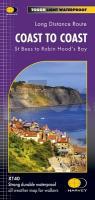
The Coast to Coast is a 307km (192 miles) walking route across northern England, passing through the Lake District, Yorkshire Dales and North York Moors National Parks. It connects the west coast (St Bees) with the east coast (Robin Hood`s Bay).

This map shows the entire route split into sections.

-Tough, light, durable and 100% waterproof
-Includes Rights of Way
-Genuine original HARVEY mapping
-Route clearly marked

Kartenausschnitt

Kartenbeispiel

Coast to Coast - St. Bees to Robin Hood´s Bay Long Distance Route - XT40 Wanderkarte 1:40.000 waterproof - HARVEY MAPS Großbritannien
EAN / ISBN: 9781851376186
Preis: EUR 26.90

Bestellartikel: versandfertig in ca. 3-7 Tagen. Dieser Artikel wird speziell für Sie bestellt. Keine Rücknahme!
Produkt EUR Anzahl Bestellen
Coast to Coast - St. Bees to Robin Hood´s Bay Long Distance Route - XT40 Wanderkarte 1:40.000 waterproof - HARVEY MAPS Großbritannien 26.90
Versandkostenfrei in Deutschland ab 30,- Bestellwert

incl. MwSt.

Stichworte, die bei der Suche nützlich sein könnten:
Coast to Coast Long Distance Route - Skipton - Kendal - Robin Hood´s Bay - Richmond - St. Bees - Whitby - Großbritannien Wanderkarten - Großbritannien Fahrradkarten - Großbritannien Mountainbike-Karten - Harvey maps - Superwalker - Schottland Wanderkarten - Großbritannien Wanderkarten - Harvay - Harway Maps - Britsh Mountain Maps - BMC - Ultramaps - XT40 - XT25 - Great Britain walking maps - UK hiking maps - Scotland hiking maps - Harveymaps - UK Walking maps - Great Britain walking maps

Zuletzt angesehene Artikel:

CoverCoast to Coast - St. Bees to Robin Hood´s Bay Long Distance Route - XT40 Wanderkarte 1:40.000 waterproof - HARVEY MAPS Großbritannien

CoverMoab Area East - Dewey Bridge, Sand Flats (Blatt 507) GPS (UT) 1:90.000 Landkarte - Trails Illustrated Map - National Geographic - USA National Geographic

CoverMountain Walking Snowdonia - 40 of the finest routes in Snowdonia - Wanderführer - Cicerone Großbritannien (englisch)