Willkommen bei MapFox
Wurde Ihre Bestellung bestätigt? Wenn nicht - gab es evtl. ein SERVER-Problem! Bitte kontaktieren Sie uns! +++ Buchhändler-Anfragen erwünscht +++
Warenkorb
Artikel: 0 - € 0.00
Zur Kasse
Impressum Kontakt Versandkosten AGB
Camino Portugués - Maps - Mapas - Mappe - Karten Camino central - Lisboa - Porto - Santiago - von John Brierley Caminoguides - Findhorn Press
<< Caminoguides - Jakobsweg
<< Jakobsweg
 
Cover

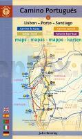
Kartenbuch über den den Streckenverlauf des Camino Portugués von Lissabon bis Santiago de Compostela. Jede Etappe mit eigenem Kartenausschnitt, Alternativrouten, Kilometrierung, Streckencharakteristik, Höhenprofil, Übernachtungs-Adressen. Maßstab ca. 1:100.000 + Detailpläne für größere Ortschaften, Sehenswürdigkeiten.

Fünfsprachige Ausgabe: Englisch, Spanisch, Portugiesisch, Italienisch und Deutsch.

Gewicht 90 g.

Spiritual seekers and travelers will find all the resources they need to walk the Way of St. James in this complete set of maps and town plans covering the sacred route from Lisbon, via Porto, to Santiago de Compostela. This newly updated, portable travel companion is light enough to carry while walking long distances each day and contains maps with locations of all pilgrim hostels, the distances between villages, and points of interest, as well as alternative routes and accommodations.

Kartenausschnitt

Kartenbeispiel

Camino Portugués - Maps - Mapas - Mappe - Karten Camino central - Lisboa - Porto - Santiago - von John Brierley Caminoguides - Findhorn Press
EAN / ISBN: 9781912216314
Preis: EUR 19.90

Fehlt kurzfristig am Lager. - Versandfertig in ca. 2 Wochen oder länger.
Produkt EUR Anzahl Bestellen
Camino Portugués - Maps - Mapas - Mappe - Karten Camino central - Lisboa - Porto - Santiago - von John Brierley Caminoguides - Findhorn Press 19.90
Versandkostenfrei in Deutschland ab 30,- Bestellwert

incl. MwSt.

Stichworte, die bei der Suche nützlich sein könnten:
John Brierley - Jakobsweg - Jakobsweg Spanien - Camino Portugues - Camino Portugués - Jakobsweg - Camino de Santiago - Santiago de Compostela - Camino Primitivo - Camino Portugués - Camino Portugues - Camino Portugués - John Brierley - Findhorn Press - Jakobsweg - Santiago-de-Compostela - Santiago de Compostela - Santiago de Compostella

Zuletzt angesehene Artikel:

CoverCamino Portugués - Maps - Mapas - Mappe - Karten Camino central - Lisboa - Porto - Santiago - von John Brierley Caminoguides - Findhorn Press

CoverJ18 Regen mit Bischofsmais, Frauenau, Kirchberg im Wald, Rinchnach, Schönberg, Zwiesel ATK25 Topographische Karte 1:25.000 (Atkis) Bayern Landesvermessungsamt Bayern - Wanderkarte

CoverSüdafrika 1:1.5 Mio. ? Krüger Nationalpark ? Cape Town ? Johannesburg Autokarte und Freizeitkarte Freytag & Berndt

Cover5720 Büdingen Topographische Landkarte Hessen 1:25.000 - ProjektNord (geplottete Ausgabe)

CoverN12 Garching - Ismaning, Markt Schwaben, Neufahrn b. Freising, Moosinning, Poing, Kirchheim b. München ATK25 Topographische Landkarte 1:25.000 (Atkis) Bayern Landesvermessungsamt Bayern - Wanderkarte

Cover9 Westböhmische Bäder - Kaiserwald Wanderkarte Tschechien 1:50.000
Západoceské lázne, Slavkovský les - SHOCart

Cover27 Belgische Küste - bicycle junction maps Knotenpunkte-Fahrradkarte 1:100.000
Fietsknooppuntenkaart 27 ANWB - Belgien

Cover3528 Meinersen Amtliche topographische Karte 1:25.000 Landesvermessungsamt Niedersachsen

CoverAlberta 1:940.000 (Kanada) - Calgary - Edmonton - Banff - Jasper - Lake Louise - Landkarte - ITMB International Travel Maps (engl.)

Cover37E DELFT Topographische Karte der Niederlande 1:25.000 (Plotausgabe)
37E DELFT Topografische Kaart van Nederland Kadaster - ProjektNord

CoverBlaeu`s Europe Map (ca. 1620) Poster - Historische Landkarte ( Replikat ) - 78 x 61 cm Interkart

CoverCoast of Holland South - Wanderkarte 1:33.333 Wandelregiokaart Nederland ANWB - Niederlande

CoverAlrededor de Santiago (Rund um Santiago) 1:50.000/1:25.000 Wanderkarte - Viachile Editores - Chile

Cover306 Eis und Gletscher `Einst und Jetzt` Topographische Landeskarte der Schweiz - swisstopo

CoverN-34-107/108 Bialystok Plot aus der Kartengrundlage der amtliche topographische Karte Polen 1:100.000 ProjektNord

Cover30 Wanderungen Pfälzerwald und Deutsche Weinstraße - OutdoorHandbuch (Band 354) - Regional - von Jürgen Plogmann Conrad-Stein-Verlag

Cover424 Wipptal u. seine Seitentäler 1:25.000 - Laminierte Wanderkarte XL Edition Navistal - Schmirntal - Valser Tal - Gschnitztal - Obernbergtal - Walter Mayr - KOMPASS

Cover1748ETR Néouvielle - Vallée d`Aure - PNR des Pyrénées - Topographische Wanderkarte Frankreich 1:25.000 (LAMINIERTE AUSGABE) TOP 25 IGN - (GPS)

Noch kein Cover vorhanden334.33 Amtliche topographische Karte 1:25.000 Polen

Noch kein Cover vorhanden169 N Andøya NORD 1:50.000 - Amtliche Topographische Landkarte Norwegen - Startens Kartverk