Willkommen bei MapFox
Wurde Ihre Bestellung bestätigt? Wenn nicht - gab es evtl. ein SERVER-Problem! Bitte kontaktieren Sie uns! +++ Buchhändler-Anfragen erwünscht +++
Warenkorb
Artikel: 0 - € 0.00
Zur Kasse
Impressum Kontakt Versandkosten AGB
Karakalpakistan - von Ibbotson, Sophie Adams, Stephanie -
Karakalpakstan Bradt Guides
<< Usbekistan
<< Bradt Publications
 
Cover

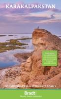
Bradt´s Karakalpakstan is the longest, most detailed and most up-to-date travel guidebook to this autonomous republic - Central Asia´s best-kept secret. With detailed information on what to see and do, listings for accommodation and restaurants, and guidance on getting around, this guide provides all the practical advice adventurous tourists need to visit or explore this exciting destination. Roughly the size of Sweden, Karakalpakstan borders Kazakhstan, Turkmenistan and Uzbekistan, and was, until recently, dominated by the Aral Sea. As the sea water has retreated, the Aralkum - the world´s newest desert - and numerous lakes have formed in its place. Ecotourism is developing rapidly here, as local people recognise the need to protect and restore fragile ecosystems while creating meaningful employment opportunities. Amid Karakalpakstan´s remote wildernesses, the intrepid traveller will find unique geology (such as the Ustyurt Plateau), rare wildlife (including a substantial population of the critically endangered saiga antelope, whose peculiarly bulbous nose helps filter desert dust and regulate the animal´s temperature), and fabulous star gazing. The region also boasts a long history and rich culture. Scattered through the Kyzylkum, the ruins of the 50-plus desert fortresses of Ancient Khorezm (some proposed as UNESCO World Heritage Sites) attest to the region´s former strategic importance. You can explore ancient settlements (such as the necropolis of Mizdakhan, said to include the grave of Adam), and see caravanserais, mausolea and even Chilpik Dakhma, a Zoroastrian ?tower of silence´. Alternatively, celebrate Russian Avant Garde art alongside the superb archaeological and ethnographic collections of Savitsky Museum in Nukus, justifiably known as the ?Louvre of the Steppe´. For something entirely different, why not explore Muynak´s ship graveyard on the remains of the Aral Sea, visit the notorious Soviet bioweapons lab Aralsk 7 on Vozrozhdeniya (Resurrection Island), raise your binoculars at the Important Bird and Biodiversity Area of Sudochye Lakes (where 230 types of birds have been recorded) or dance the night away at the annual Stihia festival of electronic music. Written by two Central Asian experts, Bradt´s Karakalpakstan is an indispensable practical companion to visiting this excitingly varied republic.

Karakalpakistan - von Ibbotson, Sophie Adams, Stephanie -
Karakalpakstan Bradt Guides
EAN / ISBN: 9781804690819
Preis: EUR 30.90

Bestellartikel: versandfertig in ca. 1-3 Wochen. Dieser Artikel wird speziell für Sie bestellt. Keine Rücknahme!
Produkt EUR Anzahl Bestellen
Karakalpakistan - von Ibbotson, Sophie Adams, Stephanie -
Karakalpakstan Bradt Guides
30.90
Versandkostenfrei in Deutschland

incl. MwSt.

Stichworte, die bei der Suche nützlich sein könnten:
Usbekistan travel guide - Aral-See - Aralsee - Usbekistan Reiseführer - Usbekistan - Uzbekistan - Bradt Publications - Bradt Reiseführer

Zuletzt angesehene Artikel:

CoverKarakalpakistan - von Ibbotson, Sophie Adams, Stephanie -
Karakalpakstan Bradt Guides

CoverUK 50-35 Landshut - Freising - Dingolfing - Mainburg - Neumarkt-Sankt-Veit Wanderkarte Bayern 1:50.000 mit Wanderwegen und Radwanderwegen, GPS-Gitter - Landesamt für Digitalisierung, Breitband und Vermessung (Landesvermessungsamt Bayern)

Noch kein Cover vorhanden3064 Stieglitz Topographische Karte 1:25.000 Messtischblatt des Deutschen Reiches - Preußische Landesaufnahme / Reichsamt für Landesaufnahme - Faksimile ProjektNord

CoverRadregion Dänemark Ost - Auf den Inseln Sjælland, Lolland, Falster und Møn Radatlas bikeline - Esterbauer

CoverNaturpark Soonwald - Nahe - (Blatt 4) Bad Kreuznach, Langenlonsheim, Bad Münster am Stein-Ebernburg, Bad Sobernheim, Rüdesheim (SN4) Topographische Wanderkarte 1:25.000 - Landesamt für Vermessung und Geobasisinformation Rheinland-Pfalz

CoverP4122 Kauhajärvi Topographische Karte 1:25.000 EUREF (Peruskartta) Maanmittauslaitos / Lantmäteriverket Finnland - ProjektNord

Noch kein Cover vorhanden2355 Basenthin Topographische Karte 1:25.000 Messtischblatt des Deutschen Reiches - Preußische Landesaufnahme / Reichsamt für Landesaufnahme - Faksimile ProjektNord

Cover28 Parco Naturale del Monte San Bartolo 1:15.000 - Wanderkarte Italien - Monti Editore
Carta dei sentieri del Parco Naturale del Monte San Bartolo Italien - Monti Editore

Cover218 Kidderminster & Wyre Forest - laminierte Wanderkarte Großbritannien 1:25.000 EXPLORER MAP - Ordnance Survey

CoverLiparische Inseln Reiseführer Michael-Müller-Verlag - Reiseführer

CoverKefalonia - Ithaka aus der Vogelperspektive Bildband
Cephalonia - Ithaki - As the seagull flies - Anavasi - Griechenland

CoverIrbit 1:10.000 / 1:100.000 Stadtplan + Umgebungskarte
Ирбит - Irbit Karta goroda i okrestnosti Navitel - FGUP - Uralaerogeodezija Russland

Noch kein Cover vorhanden3963 Priment Topographische Karte 1:25.000 Messtischblatt des Deutschen Reiches - Preußische Landesaufnahme / Reichsamt für Landesaufnahme - Faksimile ProjektNord

Noch kein Cover vorhanden1277 Kußfeld Topographische Karte 1:25.000 Messtischblatt des Deutschen Reiches - Preußische Landesaufnahme / Reichsamt für Landesaufnahme - Faksimile ProjektNord

Noch kein Cover vorhanden3053 Bad Schönfließ in der Neumark Topographische Karte 1:25.000 Messtischblatt des Deutschen Reiches - Preußische Landesaufnahme / Reichsamt für Landesaufnahme - Faksimile ProjektNord

CoverWo geht`s lang? Karten erklären die Welt - von Heekyoung Kim - Krystyna Lipka-Sztarballo (Illustr.) - 48 S. - gebunden - Ab 6 J. - Gerstenberg

Cover7141 Straubing Topographische Landkarte Bayern 1:25.000 - Normalausgabe - ProjektNord (geplottete Ausgabe) - Grundlage amtliche Topographische Karte Bayern DTK25

Cover201 Parco Nazionale Arcipelago Toscano 1:25.000/1:15.000 Wander-und Mountainbikekartenset (wasser- und reißfest) - 4land

CoverWandertrilogie Allgäu (Nr. 5422) KOMPASS

CoverRoad Map of East Azarbayejan (Blatt 414) 1:680.000 Landkarte Persisch
نقشه ر اهنماي استان آذربايجان شرقي Gitashenasi - Iran