Willkommen bei MapFox
+++ Buchhändleranfragen willkommen! Tel. 0431-666 75 99 +++
Warenkorb
Artikel: 0 - € 0.00
Zur Kasse
Impressum Kontakt Versandkosten AGB
Azoren 1:60.000 - 1:70.000 Wanderkarte - Discovery Walking Guides Ltd
Azores Tour & Trail Super-Durable Map
<< Portugal: Madeira, Azoren
<< Discovery Walking Guides Ltd.
 
Cover

For the best adventures, use the best map.
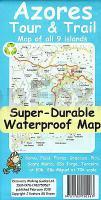
Azores Tour & Trail Super-Durable Map is the most detailed, accurate, toughest, large scale map of these 9 islands that you can buy.
Super-Durable Maps now come with a 2 year adventurous use wear and tear guarantee, see Discovery Walking Guides website for details.

1:60,000 scale for each island, Sao Miguel at 70,000 scale, produces a double sided map sheet of 960mm by 694mm; big enough to show masses of detail but compact enough to use in the car or on the trail.

Faial, Pico, Santa Maria and Sao Jorge are on the facing sheet of the map with Corvo, Flores, Graciosa, Sao Miguel and Terceira are on the reverse side.
Our special concertina map fold means your map is easy to unfold, and more importantly easy to refold back to its pocket size.
You get the most detailed map of the Azores islands that is produced including our `Tour & Trail` level of detail ranging from major roads to secondary roads to minor roads to streets and narrow country roads, plus dirt roads and walking trails.
We have a new method of highlighting the official and published walking trails. This makes it easier to identify the walking trails on the map and easier to find them on the ground. Altitude background colouring is designed to clearly show the altitude range when traveling across the islands by car or on foot.
100 metre and 20 metre contours are clearly shown on the map along with a large number of individual height points.
Tour & Trail attention to detail is legendary as is our useful symbol range including miradors, picnic areas, petrol stations, bar/restaurants and parking areas where you can pull off the road safely.

For adventurers on foot Tour & Trail Maps are researched and designed by hikers for use by hikers. Our comprehensive gps ground surveys produce the best road mapping available but the value of this on the ground research becomes even more important when you leave the tarmac.
Super-Durable editions are printed with special UV cured inks on a 100 micron plastic substrate using the only UK press equipped with this latest technology. The result of using this new technology is a Super-Durable Map that feels like silk but will stand up to the roughest treatment of outdoor adventuring and yet fold up like new at the end of your adventure.

Kartenausschnitt

Kartenbeispiel

Azoren 1:60.000 - 1:70.000 Wanderkarte - Discovery Walking Guides Ltd
Azores Tour & Trail Super-Durable Map
EAN / ISBN: 9781782750567
Preis: EUR 13.90

Dieser Titel ist momentan nicht lieferbar.
Produkt EUR Anzahl Bestellen
Azoren 1:60.000 - 1:70.000 Wanderkarte - Discovery Walking Guides Ltd
Azores Tour & Trail Super-Durable Map
13.90
Versandkostenfrei in Deutschland ab 30,- Bestellwert

incl. MwSt.

Stichworte, die bei der Suche nützlich sein könnten:
Ilha de São Miguel - Azoren Landkarte - Azoren - Azoren Radwanderkarte - Azoren Wanderkarte - Azoren Fahrradkarte - Azoren Topographische Karte - Discovery Walking Guides - Kanarische Inseln Wanderkarten - Madeira Wanderkarten - Madeira - Azoren

Zuletzt angesehene Artikel:

CoverAzoren 1:60.000 - 1:70.000 Wanderkarte - Discovery Walking Guides Ltd
Azores Tour & Trail Super-Durable Map

CoverL3412 Mynämäki Topographische Karte 1:25.000 EUREF (Peruskartta) Maanmittauslaitos / Lantmäteriverket Finnland - ProjektNord

CoverSiemianówka und Umgebung 1:50.000 - Touristische Landkarte und Wanderkarte Polen
SIEMIANÓWKA i OKOLICE Agencja TD - Polen

Cover1: Ost- und Westflandern Fahrradkarte 1:75.000
Oost & West-Vlaanderen fietskaart Alta Via - Belgien

CoverV423 Enontekiö Topographische Karte 1:50.000 EUREF-FIN (Maastokarttat) Maanmittauslaitos / Lantmäteriverket Finnland - ProjektNord

CoverMoskau und Umgebung - Einkaufsmöglichkeiten 1:300.000 Straßenkarte
Karta-putewoditel: Moskwa - Podmoskowe - Torgowaja set Rus Co. Ltd. - Russland

Cover2716 Elsfleth Amtliche topographische Karte 1:25.000 Landesvermessungsamt Niedersachsen

Cover2909 Rhede an der Ems Amtliche topographische Karte 1:25.000 Landesvermessungsamt Niedersachsen

Noch kein Cover vorhanden2258 Regenwalde Topographische Karte 1:25.000 Messtischblatt des Deutschen Reiches - Preußische Landesaufnahme / Reichsamt für Landesaufnahme - Faksimile ProjektNord

Noch kein Cover vorhandenErläuterungen zur Geologischen Karte 5344 Marienberg-Wolkenstein (128) - Ausgabe 1903 Sächsisches Landesamt für Umwelt, Landwirtschaft und Geologie

CoverN4443 Kodanovisenselkä Topographische Karte 1:25.000 EUREF (Peruskartta) Maanmittauslaitos / Lantmäteriverket Finnland - ProjektNord

CoverPays du Barrois - Meuse sud Freizeit und Ausflugs-Landkarte 1:50.000 Plein Air - IGN Frankreich

CoverAustralia Motorcycle Atlas - 200 Top Rides B5 Spiralbindung HEMA Maps Australien

CoverMönchengladbach 1962 (Blatt 35) Historischer Bildstadtplan Bollmann-Bildkarten-Verlag

CoverN07 Thannhausen - Ursberg, Kirchheim i.Schw., Fischach, Langenneufach, Markt Wald, Ziemetshausen ATK25 Topographische Karte 1:25.000 (Atkis) Bayern Landesvermessungsamt Bayern - Wanderkarte

CoverKaschubien touristische Sehenswürdigkeiten 1:175.000 Touristische Landkarte
Kaszuby atrakcje turystyczne mapa EkoKapio CartoMedia - Polen

CoverBaedeker Reiseführer Korsika von Maunder, Hilke u. Reincke Dr., Madeleine

Cover10056 Besseggen - Bygdin Topographische Landkarte 1:50.000 Norge-serien - Nordeca Norwegen

CoverWeliki Nowgorod 1:10.000 Stadtplan - Russland
Великий Новгород. Карта города Rus Co. Ltd.