Willkommen bei MapFox
+++ Buchhändleranfragen willkommen! Tel. 0431-666 75 99 +++
Warenkorb
Artikel: 0 - € 0.00
Zur Kasse
Impressum Kontakt Versandkosten AGB
Greek Waters Pilot *** SCHNÄPPCHEN *** Rod Heikell - IMRAY
A yachtsman`s guide to the Ionian and Aegean coasts and islands of Greece
<< Griechenland
<< Schnäppchen - Restposten - Mängelexemplare
 
Cover

Altauflage 2018, daher zum Sonderpreis.

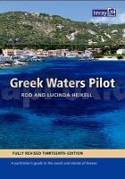
Greek Waters Pilot is the definitive cruising guide to the coasts and islands of Greece. It covers the entire area from the Ionian Islands to the Aegean, Rhodes and Crete and includes details of over 450 harbours in a single volume. Greek Waters Pilot has been painstakingly compiled from the author’s own survey work and the latest first-hand information.

The organisation of so much detail within the confines of a single volume is an impressive achievement and has been the basis of Greek Waters Pilot’s status as the indispensable guide for anyone sailing around Greece.

This 13th edition contains detailed updating of every part of the guide, but in particular areas of the Ionian, Saronic and northern Greece, visited by the authors since the last edition, have major revisions. Many new photos, often from the air, have been introduced. There are also many new harbour plans.

Imray Digital Charts: Free mobile download
A voucher code to download the relevant Imray digital charts into Imray Navigator (our app for iPad and iPhone) is included with this book.

Kartenausschnitt

Kartenbeispiel

Greek Waters Pilot *** SCHNÄPPCHEN *** Rod Heikell - IMRAY
A yachtsman`s guide to the Ionian and Aegean coasts and islands of Greece
Preis: EUR 24.90

sofort versandfertig Dieser Artikel ist im Normalfall sofort lieferbar.
Produkt EUR Anzahl Bestellen
Greek Waters Pilot *** SCHNÄPPCHEN *** Rod Heikell - IMRAY
A yachtsman`s guide to the Ionian and Aegean coasts and islands of Greece
24.90
Versandkostenfrei in Deutschland

incl. MwSt.

Stichworte, die bei der Suche nützlich sein könnten:
Ionische Küste Griechenland Segelführer (Hafenführer) - Griechische Gewässer Segelführer (Hafenführer) - Ägäische Küste Griechenland Segelführer (Hafenführer) - Griechenland - Griechenland Kartografie - Griechenland Atlanten - Griechenland Landkartenverkauf - Griechenland Wanderkarten - Griechenland Reiseführer - Griechenlandkarten - Griechenland Kartographie - Griechenland Straßenkarten - Griechenland Radwanderkarten - Griechenland Landkarten - Griechenland Radwanderführer - Griechenland Fahrradkarten - Griechenland Karten - Griechische Karten - Griechische Landkarten - Schnäppchen - Sonderangebote - Restposten

Zuletzt angesehene Artikel:

CoverGreek Waters Pilot *** SCHNÄPPCHEN *** Rod Heikell - IMRAY
A yachtsman`s guide to the Ionian and Aegean coasts and islands of Greece

Cover0501-1 RETORTILLO Topographische Landkarte 1:25.000 Spanien (Grundlage MTN25) Instituto Geográfico Nacional - CNIG Spanien - ProjektNord

Noch kein Cover vorhandenWest Virginia Atlas & Gazetteer - Topographischer Straßenatlas Delorme Publishing Company DELORME MAPPING USA

CoverSlowenisch - Wort für Wort Kauderwelsch-Sprachführer (Band 069) Slowenien - Reise-Know-How Verlag

Cover0475 LUMBRALES Topographische Landkarte 1:50.000 Spanien (Grundlage MTN50) Instituto Geográfico Nacional - CNIG Spanien - ProjektNord

Cover352 Islay South - Port Ellen - Bowmore & Bridgend - Wanderkarte Großbritannien 1:25.000 EXPLORER MAP - Active Map LAMINIERT - Ordnance Survey

Cover0511 BRIHUEGA Topographische Landkarte 1:50.000 Spanien (Grundlage MTN50) Instituto Geográfico Nacional - CNIG Spanien - ProjektNord

CoverVeloland Schweiz Bd.3 Nord-Süd Route WerdVerlag

Cover1190 MELCHTAL 1:25.000 - Giswil - Sarnersee - Stöckalp - Topographische Landeskarte der Schweiz - swisstopo

Cover0361 CERVERA Topographische Landkarte 1:50.000 Spanien (Grundlage MTN50) Instituto Geográfico Nacional - CNIG Spanien - ProjektNord

Cover0532-1 NAVALPERAL DE PINARES Topographische Landkarte 1:25.000 Spanien (Grundlage MTN25) Instituto Geográfico Nacional - CNIG Spanien - ProjektNord

CoverAlpi Marittime e Liguri Wanderführer (italienisch) Club Alpino Italiano - STUDIO CARTOGRAFICO ITALIANO - Italien

Cover0662-4 VALVERDE DE JÚCAR Topographische Landkarte 1:25.000 Spanien (Grundlage MTN25) Instituto Geográfico Nacional - CNIG Spanien - ProjektNord

Cover0768-4 EL CORRALEJO Topographische Landkarte 1:25.000 Spanien (Grundlage MTN25) Instituto Geográfico Nacional - CNIG Spanien - ProjektNord

CoverWalking in the Wye Valley 30 walks Wanderführer - Cicerone (englisch)

Cover0839 TORRE DE JUAN ABAD Topographische Landkarte 1:50.000 Spanien (Grundlage MTN50) Instituto Geográfico Nacional - CNIG Spanien - ProjektNord

Cover0921-3 EL AGUILA Topographische Landkarte 1:25.000 Spanien (Grundlage MTN25) Instituto Geográfico Nacional - CNIG Spanien - ProjektNord

CoverAconcagua and the Southern Andes - The Highest Trek in the World - Wanderführer - Cicerone (englisch)

Cover0528 GUIJUELO Topographische Landkarte 1:50.000 Spanien (Grundlage MTN50) Instituto Geográfico Nacional - CNIG Spanien - ProjektNord

CoverWashington D.C Street Map Stadtplan - Rand McNally - USA