Willkommen bei MapFox
+++ Buchhändleranfragen willkommen! Tel. 0431-666 75 99 +++
Warenkorb
Artikel: 0 - € 0.00
Zur Kasse
Impressum Kontakt Versandkosten AGB
Oklahoma Recreation Map 1:633.600 - Landkarte Benchmark Map USA
<< USA: Wanderkarten, Nationalpark-Karten
<< Benchmark
 
Cover

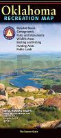
The Oklahoma Recreation Map is the first map product to accurately represent The Sooner State`s highway detail and the richness of recreation opportunities. One side provides a full state map that features Public & Tribal Lands, land cover (forest, grassland, cropland, & wetland), extensive highway networks, point-to-point mileages, recreation sites, Roadside America attractions, campgrounds, parks & wildlife areas, boating & fishing access points, and public hunting areas. The reverse side features categorized recreation listings with helpful descriptions, current contact information, and map grid references.

Oklahoma Recreation Map 1:633.600 - Landkarte Benchmark Map USA
EAN / ISBN: 9780783499208
Preis: EUR 11.90

Bestellartikel: versandfertig in ca. 1-3 Wochen. Dieser Artikel wird speziell für Sie bestellt. Keine Rücknahme!
Produkt EUR Anzahl Bestellen
Oklahoma Recreation Map 1:633.600 - Landkarte Benchmark Map USA 11.90
Versandkostenfrei in Deutschland ab 20,- Bestellwert

incl. MwSt.

Stichworte, die bei der Suche nützlich sein könnten:
USA Wanderkarten - USA Landkarten - USA Nationalparks - USA National Parks - USA maps - Vereinigte Staaten Landkarten - USA Nationalpark-Karten - Benchmark - Benchmark Recreation maps - Benchmark Road Maps - Benchmark Roadatlases - Benchmark Atlanten - USA Atlanten - USA Recreation Atlases - Bundesstaatenkarten USA - Amerikanische Bundesstaaten - Vereinigte Staaten von Amerika Landkarte - US maps - US states maps

Zuletzt angesehene Artikel:

CoverOklahoma Recreation Map 1:633.600 - Landkarte Benchmark Map USA

Cover459 Central Lewis & Stornaway - laminierte Wanderkarte Großbritannien 1:25.000 EXPLORER MAP - Ordnance Survey

Cover601-1 CUEVA DEL ÁGUILA Amtliche topographische Landkarte 1:25.000 Spanien (M.T.N.)
601-1 Mapa Topográfico Nacional de Espana (MTN25) Instituto Geográfico Nacional - CNIG Spanien

CoverKaposvar (Kopisch / Ruppertsburg / Ruppertsberg) Stadtplan
Kaposvár térkép Hiszi-Map Ungarn

Cover1Q84. Buch 3 Roman von Haruki Murakami - DuMont Buchverlag

CoverMARCO POLO Regionalkarte Italien 04 Venetien, Friaul, Gardasee 1:200.000

Cover1044 01 Askainen Topographische Karte 1:20.000 (Maastokartta / Peruskartta / Grundkarta) Maanmittauslaitos / Lantmäteriverket Finnland - ProjektNord

CoverWandertouren in der Oslomark Wanderführer (schwedischsprachig)
Vandringsturer i Oslomarka Vildmarksbiblioteket Schweden

CoverFreiberger Mulde - Freiberg (Blatt 24) Topographische Wanderkarte 1:25.000 mit Wanderwegen - ProjektNord

CoverKorinthos (Blatt 204) Stadtplan 1:10.000
Κόρινθος Orama - Griechenland

CoverMARCO POLO Länderkarte Polen

CoverLonely Planet Reiseführer Cornwall & Devon

CoverElsass - Vogesen Nord / Alsace - Vosges du Nord (Nr. 2220) Wanderkarten-Set mit Aktiv Guide. GPS-genau. 1:50.000 KOMPASS-Karten

CoverCoesfeld Topographische Wanderkarte Nordrhein-Westfalen mit Wanderwegen und Radwegen 1:25.000 - ProjektNord

Cover2513-II-SV Topographische Karte Dänemark 1:25.000
Topografisk kort Danmark (DTK/Kort25) 2513-II-SV ProjektNord - Kort & Matrikelstyrelsen / Geodætisk Institut

Noch kein Cover vorhanden321 - Topographische Landkarte Portugal 1:25.000 Carta Militar de Portugal - Série M889 Instituto Geográfico do Exército (IGeoE) - Portugal

Noch kein Cover vorhanden178 - Topographische Landkarte Portugal 1:25.000 Carta Militar de Portugal - Série M889 Instituto Geográfico do Exército (IGeoE) - Portugal

CoverWanderführer Alpinwandern Graubünden Nord Schweizer Alpen-Club

Noch kein Cover vorhandenErläuterungen zur Geologischen Karte 4843 Leisnig-Hartha (45) - Ausgabe 1897 Sächsisches Landesamt für Umwelt, Landwirtschaft und Geologie

CoverGroßherzogtum Weimar-Eisenach 1817 - Historische Landkarte Nachdruck Planokarte - gerollt von Weiland, Carl - Verlag Rockstuhl