Willkommen bei MapFox
+++ Buchhändleranfragen willkommen! Tel. 0431-666 75 99 +++
Warenkorb
Artikel: 0 - € 0.00
Zur Kasse
Impressum Kontakt Versandkosten AGB
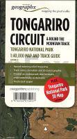
Tongariro Circuit & Round the Mountain Track 1:40.000 + Track Guide Wanderkarte - Neuseeland Geographx - Craig Potton Publishing Neuseeland
<< Neuseeland
<< Potton & Burton / Craig Potton Publishing
 
Cover

Established in 1887, Tongariro was the first national park in New Zealand and the fourth in the world. It is also a dual World Heritage area, a status which recognises the park`s important Maori cultural and spiritual associations as well as its outstanding volcanic features.

It is a place of extremes and surprises, a place to explore and remember. From herb fields to forests, from tranquil lakes to desert-like plateau and active volcanoes - Tongariro has them all.
Tongariro National Park is located in the central North Island of New Zealand. It is the closest national park to Auckland, New Zealands largest city, and is very accessible from State Highway 1. The nearest towns are Turangi, National Park and Ohakune.

Features:

- Additional Tongariro National Park 3D Map on reverse
- Award-winning relief mapping
- Track notes, elevation and distance graphic
- Printed on waterproof, tear-resistant, environmentally sustainable `Rockstock` paper.

Kartenbeispiel aus der Serie

Mit zusätzlicher Panoramakarte der weiteren Umgebung

Kartenausschnitt

Tongariro Circuit & Round the Mountain Track 1:40.000 + Track Guide Wanderkarte - Neuseeland Geographx - Craig Potton Publishing Neuseeland
EAN / ISBN: 9416458075407
Preis: EUR 24.90

Dieser Titel ist momentan nicht lieferbar.
Produkt EUR Anzahl Bestellen
Tongariro Circuit & Round the Mountain Track 1:40.000 + Track Guide Wanderkarte - Neuseeland Geographx - Craig Potton Publishing Neuseeland 24.90
Versandkostenfrei in Deutschland

incl. MwSt.

Stichworte, die bei der Suche nützlich sein könnten:
Tongariro Nationalpark - Neuseeland - New Zealand - Tongariro National Park - Neuseeland Wanderkarte - Mount Ruapehu - Tongariro Circuit - Neuseeland - Neuseeland Wanderkarten - Neuseeland Karten - Neuseeland Radwanderführer - Neuseeland Kartographie - Neuseeland Landkarten - Neuseeland Fahrradkarten - Neuseelandkarten - Neuseeland Atlanten - Neuseeland Landkartenverkauf - Neuseeland Reiseführer - Neuseeland Straßenkarten - Neuseeland Kartografie - Neuseeland Radwanderkarten - New Zealand - New Zealand Radwanderkarten - New Zealand Kartographie - New Zealand Landkarten - New Zealand Straßenkarten - New Zealand Fahrradkarten - New Zealandkarten - New Zealand Reiseführer - New Zealand Radwanderführer - New Zealand Kartografie - New Zealand Atlanten - New Zealand Landkartenverkauf - New Zealand Wanderkarten - New Zealand Karten - Neuseeland Wanderkarten - Neuseland Wanderführer - Neuseeland Trekkingführer - New Zealand - Neuseeland - Craig Potton Publishing - Craig Potton Landkarten - Craig Potton Trekkingkarten - Neuseeland Nationalpark-Karten - Neuseeland Karten - Neuseeland Wandern - New Zealand hiking maps - New Zealand trekking - New Zealand national parks

Zuletzt angesehene Artikel:

CoverTongariro Circuit & Round the Mountain Track 1:40.000 + Track Guide Wanderkarte - Neuseeland Geographx - Craig Potton Publishing Neuseeland

CoverOsteuropa 1:2 Mio. Auto- + Freizeitkarte
Eastern Europe - Europa del Este - Oost Europa - Europa de l` Est - Europa orienta freytag & berndt

CoverElsass - Vogesen - Wandern & Einkehren - 50 Touren - mit GPS-Daten - Bergverlag Rother

Cover1128 LANGENTHAL 1:25.000 - Madiswil - Huttwil - Zell - Topographische Landeskarte der Schweiz - swisstopo

Cover234 WILLISAU 1:50.000 - Langenthal - Huttwil - Sursee - Topographische Landeskarte der Schweiz - swisstopo

CoverAnnapurna - Nepal 1:135.000 (Blatt 3003) Adventure Map - National Geographic

CoverUnjustifiable Risk? the story of british climbing Cicerone (englisch)

Cover214 LIESTAL 1:50.000 - Rheinfelden - Sissach - Fricktal - Topographische Landeskarte der Schweiz - swisstopo

CoverBordeaux Stadtplan 1:15.000 Mini comfort!map wasserfest - laminiert - ExpressMap

Cover1032 DIESSENHOFEN 1:25.000 - Feuerthalen - Thayngen - Stein a. Rh. - Topographische Landeskarte der Schweiz - swisstopo

CoverTansania - das Land am Kilimandscharo 1:1.5 Mio. - World Compact Series freytag & berndt

CoverCopenhagen city map Planungskarte (engl.) Lonely Planet

CoverGunks Climbing Wolverine Publishing Llc

CoverEverest Base Camp - Nepal 1:50.000 (Blatt 3001) Adventure Map - National Geographic

CoverNantes Stadtplan 1:15.000 Mini comfort!map wasserfest - laminiert - ExpressMap

CoverTelsche 1:10.000 Stadtplan (Litauen) - Briedis
Telšiai

CoverDUMONT direkt Sylt von Kobiella, Rayka

CoverTibet 1:2.4 Mio. (CR710) Himalayan MapHouse - Nepal
Tibet - Nepal - Sikkim - Bhutan

CoverLivigno Wanderkarte 1:25.000
Livigno Carta Escursionistica L.A.C. GlobalMap Italien

CoverTour of Monte Rosa - Trekking Map 1:40.000 Switzerland & Italy - Knife Edge Outdoor Guidebooks